Granite Gaps Reference Map
Earth Science & Physical Geography Northern Appalachian Orogeny • White Mountains
Geomorphic Survey: The Four Historic Notches
Regional structural orientation map showing glacial breaches, transit corridors, settlement network, and fluvial drainage divides
SCALE 1 : 250,000
Lambert Conformal Projection
VERMONT / CT RIVER BASIN MAINE STATE LINE Androscoggin Watershed Saco River Incision Pemigewasset (Merrimack Basin) Ammonoosuc R. Lk. Gloriette US 2 NH 26 I-93 US 302 NH 16 NH 112 (KANC) 1. DIXVILLE NOTCH 1,997 FT COL Geomorph: Glacial Meltwater Spillway Lithology: Pelitic Slates & Knife Spires Connects: Upper CT to Androscoggin 2. FRANCONIA NOTCH 1,950 FT TROUGH Geomorph: U-Shaped Glacial Valley Lithology: Conway Granite Exfoliation Features: Cannon Cliff (Old Man Site) Divide: Pemigewasset / Merrimack R. 3. CRAWFORD NOTCH 1,917 FT DEFILE Geomorph: Fluvial Incision & Mass Wasting Hazards: 1826 Willey Debris Avalanche Features: Silver Cascade, Webster Cliffs Divide: Saco (Atlantic) / Ammonoosuc (CT) 4. PINKHAM NOTCH 2,032 FT COL Geomorph: Alpine Col & Drainage Divide Cirques: Tuckerman & Huntington Ravines Climate: Extreme Orographic Precipitation Divide: Peabody (N) / Ellis River (S) MT. WASHINGTON 6,288 ft Mt. Lafayette (5,249') Cannon (4,080') Wildcat (4,422') Mt. Webster (3,910') Table Rock (2,540') Colebrook Errol Groveton Milan Lancaster Jefferson Berlin Gorham Shelburne Whitefield Littleton Bethlehem Franconia Sugar Hill Twin Mountain Bretton Woods Jackson Glen Bartlett Intervale North Conway Conway Lincoln N. Woodstock Passaconaway Waterville Valley Tamworth N E W S GRAPHIC SCALE (MILES) 0 5 10 15 20 mi HIGH SCHOOL GEOMORPHIC LEGEND Glacial Col / Mountain Notch Breach Primary Alpine Summit & Spot Height Interstate 93 (Glacial Valley Parkway) US Highway (Route 302 / 2 / 3) State Highway (NH-16 / NH-26) Scenic Mountain Byway (NH 112) Primary Gateway Municipality / Settlement
Glacial Mechanism: Laurentide Ice Sheet (~14,000 BP) Highest Col: Pinkham (2,032 ft) Max Relief: Franconia (1,200 ft sheer wall) Tectonic Origin: Acadian Orogeny
PAGE 1 OF 2
Advanced Earth Science Glacial Geomorphology • Lithologic Controls • Watershed Dynamics
Structural Anatomy of the Four Notches
Topographic profiles, glacial cross-sections, bedrock lithology, and hydrographic drainage divides
WHITE MTN BATHOLITH & COÖS COMPLEX
North Woods • Coös Terrane
Dixville Notch
1,997 ft Col
Lake Gloriette (Tarn) Table Rock Arete (2,540') NH Route 26 Pelitic Slate Spires
Bedrock Lithology: Littleton Fm. (Pelitic Schist & Slate)
Primary Process: Subglacial Spillway & Frost Wedging
Drainage Divide: Mohawk R. (CT Basin) / Clear Stream
Geomorphic Features:
Steeply tilted metamorphic strata producing knife-edge aretes (Table Rock), vertical scree talus chutes, and hanging waterfall knickpoints (Huntington Falls).
Kinsman-Franconia • Grafton Terrane
Franconia Notch
1,950 ft Trough
Old Man Joint (1,200') Cannon (4,080') Lafayette (5,249') I-93 Parkway Profile Lake (Tarn)
Bedrock Lithology: Conway Granite & Kinsman Granodiorite
Primary Process: Continental Glacial Trough & Exfoliation
Drainage Divide: Pemigewasset (Merrimack) / Gale R. (CT)
Geomorphic Features:
1,200-ft sheer granitic walls shaped by exfoliation sheet jointing; subglacial meltwater potholes (The Basin) and orthogonal joint gorge cutting (The Flume).
Presidential-Willey • Coös / Carroll
Crawford Notch
1,917 ft Defile
Webster Cliffs (3,910') Mt. Willey (4,285') Silver Cascade US Route 302 1826 Slide
Bedrock Lithology: White Mountain Plutonic-Volcanic Series
Primary Process: Fluvial Re-Incision & Mass Wasting
Drainage Divide: Saco R. (Atlantic) / Ammonoosuc (CT Basin)
Geomorphic Features:
Steep V-to-U defile; catastrophic debris avalanches (1826 Willey slide down 40° granite dip-slopes); hanging tributaries generating cascade waterfalls over granitic ledges.
Presidential-Carter • Coös Terrane
Pinkham Notch
2,032 ft Saddle
Mt. Washington (6,288') Tuckerman Cirque Wildcat (4,422') NH Route 16 AMC Visitor Center
Bedrock Lithology: Rangeley & Perry Mountain Metamorphics
Primary Process: Alpine Cirque Nivation & Orographic Uplift
Drainage Divide: Peabody (Androscoggin) / Ellis (Saco)
Geomorphic Features:
High drainage col between Presidential and Carter ranges; leeward snow-drift accumulation fueling alpine cirques (Tuckerman & Huntington headwalls); Glen Ellis plunge waterfall.
High School Geoscience Matrix: Geomorphic Mechanics & Watershed Divides USGS & NH GEOLOGICAL SURVEY (NHGS)
| Notch Pass | Elevation | Dominant Bedrock | Glacial / Fluvial Morphology | Drainage Basin Divide | Primary Geohazard / Feature |
|---|
| Dixville Notch | 1,997 ft | Pelitic Slate & Phyllite | Subglacial Spillway Defile | Connecticut vs. Androscoggin | Freeze-thaw spires; rockfall talus |
| Franconia Notch | 1,950 ft | Conway Granite Pluton | U-Shaped Glacial Trough | Merrimack vs. Connecticut | Exfoliation failure (Old Man 2003) |
| Crawford Notch | 1,917 ft | Syenite & Granitic Ring Dikes | Structurally Controlled Fault Defile | Saco River vs. Connecticut | Dip-slope debris avalanche (Willey 1826) |
| Pinkham Notch | 2,032 ft | Rangeley Gneiss & Schist | Alpine Col & Cirque Headwalls | Androscoggin vs. Saco River | Orographic precipitation & snow avalanches |
Glacial Col A high saddle-like depression breached along an arete by opposing glacial cirques or subglacial meltwater.
Exfoliation Jointing Mechanical weathering where concentric slabs peel outward due to overburden release and freeze-thaw cycles.
Drainage Divide A topographic ridgeline separating watersheds; runoff on opposing flanks flows into separate fluvial basins.
Orographic Lift Forced ascent of air over mountain barriers, inducing adiabatic cooling and localized heavy precipitation.
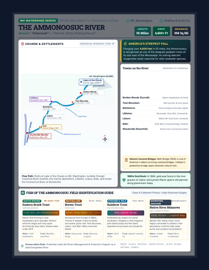
Field Nomenclature: In New England, "notch" designates an antecedent transverse water gap or glacial col dissecting an orogenic axis. PAGE 2 OF 2