Indiana Regions Handout
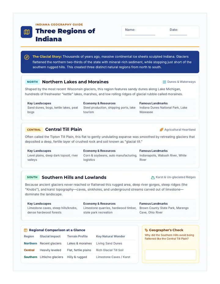
Indiana Geography Guide
Three Regions of Indiana
Name:
Date:
The Glacial Story: Thousands of years ago, massive continental ice sheets sculpted Indiana. Glaciers flattened the northern two-thirds of the state with mineral-rich sediment, while stopping just short of the southern rugged hills. This created three distinct natural regions from north to south.
North
Northern Lakes and Moraines
Dunes & Waterways
Shaped by the most recent Wisconsin glaciers, this region features sandy dunes along Lake Michigan, hundreds of freshwater "kettle" lakes, marshes, and low rolling ridges of glacial rubble called moraines.
Key Landscapes Sand dunes, bogs, kettle lakes, peat bogs
Economy & Resources Steel production, shipping ports, lake tourism
Famous Landmarks Indiana Dunes National Park, Lake Wawasee
Central
Central Till Plain
Agricultural Heartland
Often called the Tipton Till Plain, this flat to gently undulating expanse was smoothed by retreating glaciers that deposited a deep, fertile layer of crushed rock and soil known as "glacial till."
Key Landscapes Level plains, deep dark topsoil, river valleys
Economy & Resources Corn & soybeans, auto manufacturing, logistics
Famous Landmarks Indianapolis, Wabash River, White River
South
Southern Hills and Lowlands
Karst & Un-glaciated Ridges
Because ancient glaciers never reached or flattened this rugged area, deep river gorges, steep ridges (the "Knobs"), and karst topography—caves, sinkholes, and underground streams carved out of limestone—dominate the landscape.
Key Landscapes Limestone caves, steep hills/knobs, dense hardwood forests
Economy & Resources Limestone quarries, hardwood timber, state park recreation
Famous Landmarks Brown County State Park, Marengo Cave, Ohio River
Regional Comparison at a Glance
| Region |
Glacial Impact |
Terrain Profile |
Key Natural Wonder |
| Northern |
Recent glaciers |
Lakes & moraines |
Living Sand Dunes |
| Central |
Heavily leveled |
Flat, fertile plains |
Rich Glacial Till Soil |
| Southern |
Little/no glaciers |
Hilly & rugged |
Limestone Caves / Karst |
Geographer's Check
Why did the Southern Hills avoid being flattened like the Central Till Plain?
Indiana Regions Worksheet
Student Activity Sheet
Indiana Regions Worksheet
Name:
Date:
Period:
Directions: Use your Indiana Regions Handout to complete the identification, vocabulary, and analysis questions below.
1 Part 1: Regional Match-Up
Write: N (Northern), C (Central), or S (Southern)
1. Famous for deep limestone caves & sinkholes
4. Contains the living sand dunes along Lake Michigan
2. Exceptionally flat plains covered with rich glacial till
5. Home to Indianapolis and the state's corn belt
3. Rugged, un-glaciated hills and steep "knobs"
6. Dotted with hundreds of freshwater kettle lakes
2 Part 2: Geographical Vocabulary
Word Bank: Glacial Till • Karst • Moraine • Kettle Lake • Limestone
1. A low hill or ridge formed by rocks and rubble deposited by a melting glacier is a .
2. The deep mixture of clay, sand, and crushed mineral rock left by glaciers is called .
3. A landscape characterized by sinkholes, caves, and underground drainage is termed topography.
4. A hollow formed by a buried block of glacier ice that melted creates a .
5. The valuable sedimentary rock quarried in southern Indiana used in famous national buildings is .
3 Part 3: Field Explorer Scenarios
Read each explorer log and name the specific Indiana region being observed.
Log Entry A
"We hiked along steep hardwood ridges and explored a cool subterranean cavern filled with stalactites. Nearby, giant open quarries cut blocks of white building stone."
Region:
Log Entry B
"Miles of horizon-to-horizon corn and soybean fields spread out around us. The terrain is strikingly flat, traversed by major interstates leading into the state capital."
Region:
4 Part 4: Geographer's Synthesis
Explain why the physical geography of the Central Till Plain led to major agriculture, whereas the Southern Hills and Lowlands developed industries like limestone quarrying and timber harvesting.