6
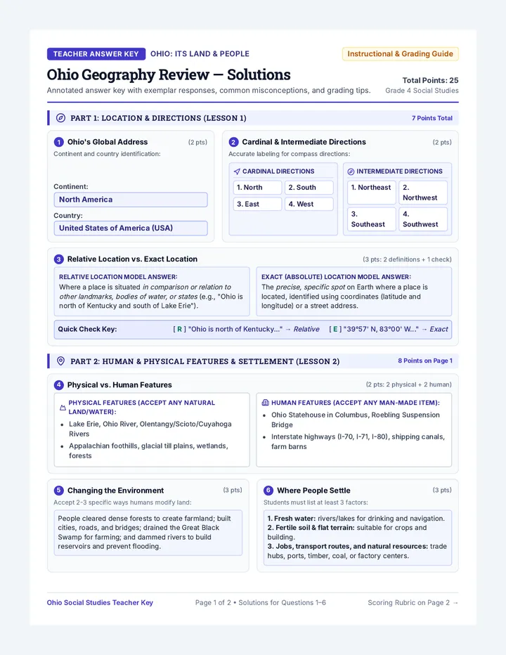
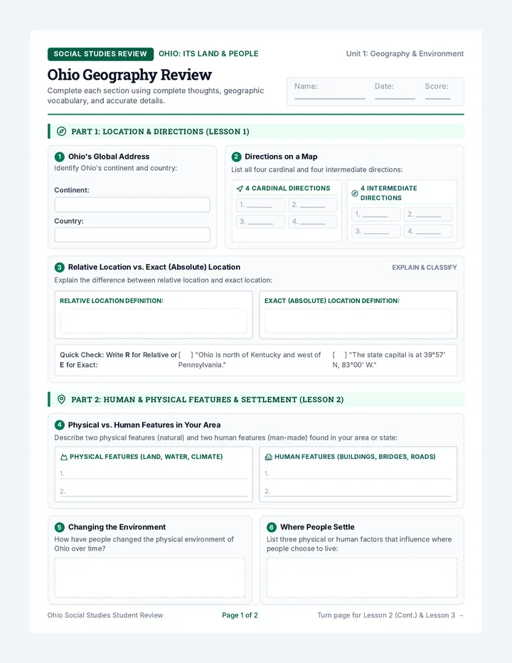
Where People Settle
(3 pts)
Students must list at least 3 factors:
1. Fresh water: rivers/lakes for drinking and navigation.
2. Fertile soil & flat terrain: suitable for crops and building.
3. Jobs, transport routes, and natural resources: trade hubs, ports, timber, coal, or factory centers.
Ohio Social Studies Teacher Key Page 1 of 2 • Solutions for Questions 1–6 Scoring Rubric on Page 2 →
Answer Key Part 2 & 3
Remaining Points: 15 / 25 Total
7
Comparing Environmental Effects (Lesson 2)
4 Points (1 pt per example)
Evaluate student responses using the exemplar criteria below:
Example 1 (Agriculture/Food):
Clearing land and tiling fields allows large-scale food production (corn, soybeans, wheat) to feed cities and drive the state economy.
Example 2 (Infrastructure/Protection):
Constructing roads, bridges, and locks/dams connects people for trade, prevents catastrophic floods, and creates reservoirs for water.
Example 1 (Habitat & Ecosystems):
Deforestation and draining wetlands destroys habitats for native wildlife (e.g., deer, migratory birds, fish) and reduces biodiversity.
Example 2 (Pollution & Erosion):
Runoff from paved surfaces and farm fertilizers pollutes waterways (algal blooms in Lake Erie), while exposed soil causes erosion.
8 Points (Q8: 2 pts, Q9: 3 pts, Q10: 3 pts)
8
What Regions Have in Common
(2 pts)
Expected core concept:
Places in a region share common physical or human characteristics that make the area different from surrounding areas. These shared features include similar landforms, climate, natural resources, culture, or economic industries.
9
Plains vs. Hills in Regions
(3 pts)
Expected regional distinction:
Plains regions: The Till Plains (western/central Ohio) and Lake Plains (northern coast) are flat or gently rolling land.
Hilly regions: The Appalachian Plateau (eastern & southeastern Ohio) is characterized by steep hills, valleys, and rugged ridges.
10
What Makes Each Region Unique?
(3 pts: 1 pt per column)
Look for distinct landforms and economic adaptations in each box:
Till Plains (Interior)
Features: Extremely rich glacial soil, flat to gently rolling land.
Economy: Prime agricultural heartland (corn, soybeans, livestock, dairy).
Lake Plains (Coast)
Features: Flat lakebed plain, sandy shoreline, Lake Erie access.
Economy: Shipping ports, commercial fishing, vineyards/orchards, manufacturing.
Appalachian Plateau
Features: High elevation, steep hills, rocky cliffs, deep stream valleys.
Economy: Coal mining, clay, sandstone, timber, outdoor tourism/parks.
Geographer's Checkpoint Model Response & Scoring Rubric
3 Points
Exemplar Synthesis Answer: "Ohio's natural waterways (Lake Erie and the Ohio River) provided critical shipping routes that turned Cleveland and Cincinnati into bustling industrial hubs, while the flat, nutrient-rich soils of the Till Plains allowed central and western Ohio to grow as a leading agricultural and trade center."
23–25 pts: Advanced Mastery
19–22 pts: Proficient
15–18 pts: Basic / Review Needed
< 15 pts: Intervention Required
Ohio Social Studies Teacher Key Page 2 of 2 • Assessment Guide Answer Key • For Educator Use