Cartography Quest Slides
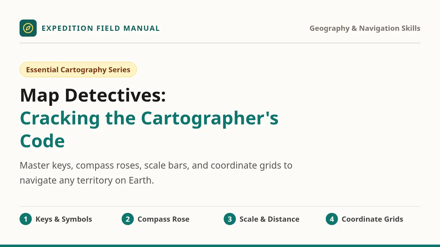
Expedition Field Manual
Geography & Navigation Skills
Essential Cartography Series
Map Detectives:
Cracking the Cartographer's Code
Master keys, compass roses, scale bars, and coordinate grids to navigate any territory on Earth.
1 Keys & Symbols
2 Compass Rose
3 Scale & Distance
4 Coordinate Grids
Field Overview The 4 Map Pillars
Every Map Tells a Story with 4 Vital Tools
Maps shrink the world onto paper or screens. These four tools help us decode the world accurately.
1. Map Key (Legend)
The translator. It defines what every color, line, and symbol on the map actually means.
2. Compass Rose
The navigator. It establishes cardinal directions so travelers never lose their orientation.
3. Map Scale
The distance gauge. It converts small paper measurements into real-world miles or kilometers.
4. Coordinate Grid
The address finder. Letters and numbers cross to pinpoint exact pinpoint locations.
Detective Goal: Combine all four tools to solve complex geographic challenges!
Skill 1: Map Keys & Symbols Cartographic Visual Language
Symbols are visual shortcuts for reality.
If cartographers drew full buildings, trees, and rivers to scale, maps would be unreadable clutter.
Rule of the Map Key (Legend):
Always check the key first! A blue line usually means a river, but on transit maps it might be a train line.
Pictographic Looks like the real item (tent for campsite).
Abstract Shapes, stars, lines (star for capital city).
MAP KEY
⛺
Campsite
Overnight shelter area
⛰️
Mountain Peak
High elevation terrain
⚓
Harbor / Port
Boat dock & anchorage
🌲
Dense Forest
Timberland vegetation
Quick Check: Never guess a symbol; verify in the legend! Next: Practice →
Guided Challenge 1 Symbol Sleuth
Can you interpret the ranger's field report?
🛈 🏥 ⛽
Service Symbols
A traveler's car runs out of fuel while their teammate needs medical bandages.
Question: Which symbol saves their expedition?
〰️〰️ ━━━ - - -
Linear Symbols
Wavy lines represent rivers. Solid lines represent roads. Dashed lines represent foot trails.
Question: Where can cars NOT travel?
⭐ vs ●
City Symbols
Maps often use a solid circle for normal towns, but a star for the state or national capital.
Question: Which one hosts the government?
Turn & Talk: Why must symbols be universal across national park maps?
Skill 2: Directions & Compass True Navigation
The Compass Rose
N
S
W
E
NE
SE
SW
NW
Clockwise: N → E → S → W
Cardinal vs. Intermediate Directions
Cardinal
North, South, East, West
The 4 primary directions. Mnemonic: Never Eat Soggy Waffles.
Intermediate
NE, SE, SW, NW
The halfway points! Always name North or South first: Northeast, Southeast, Southwest, Northwest.
Golden Rule of Movement:
Your starting point is always the center of your compass!
North points to the top of standard maps unless stated otherwise. Next: Navigation Check →
Guided Challenge 2 Plot the Expedition Route
Which direction are the explorers traveling?
🏔️
Frozen Peak
🏕️
North Camp
🦅
Eagle Nest
🌲
Pine Woods
🚩
BASE CAMP
💎
Crystal Mine
🌊
Rough Coast
⚓
South Bay
🌴
Sunken Reef
Question 1:
Leave Base Camp directly to Crystal Mine?
Answer: EAST
Question 2:
From South Bay, which way leads to Base Camp?
Answer: NORTH
Question 3:
What landmark sits directly NORTHWEST of Base Camp?
Answer: FROZEN PEAK
Pro Tip: Notice how "to" and "from" change the starting perspective!
Skill 3: Scale & Distance Measuring Reality
The Map Scale bridges paper measurements to real ground.
Because maps shrink real geography, the scale bar indicates real-world miles or kilometers.
Understanding the Graphic Scale Bar
0 to 10 km
10 to 20 km
20 to 30 km
30 to 40 km
0 km 10 km 20 km 30 km 40 km
Key Ratio: 1 segment on map = 10 kilometers in real terrain
Step 1: Measure
Count the grid squares or ruler inches between points.
Step 2: Check Scale
Identify how many real km each map unit equals.
Step 3: Multiply
Map Units × Scale Value = Real Distance (e.g. 3 × 10 = 30 km).
Large scale = zoomed in close. Small scale = zoomed out wide. Next: Practice Calculation →
Guided Challenge 3 Scale in Action
Let's calculate the real distance between island stations!
Current Map Scale: 1 Grid Box = 5 Kilometers
5 km
Challenge A Direct Route
Harbor to Forest Outpost
The trail on the map measures exactly 4 grid boxes straight East.
Calculation:
4 boxes × 5 km = 20 Kilometers
Challenge B Two-Leg Hike
Campsite to Summit to Lake
Explorers hike 3 boxes North, then 2 boxes East.
Calculation:
5 total boxes × 5 km = 25 Kilometers
Class Check: If a hike is 15 kilometers, how many grid boxes is that? (Answer: 3 boxes!)
Skill 4: Coordinates & Grids Precision Location
A
B
C
1
🏕️ A1
🌊 B1
⛰️ C1
2
🌲 A2
👑 B2 (Treasure)
⚓ C2
How Alphanumeric Coordinates Work
Columns have letters (across top), rows have numbers (down side). They cross to pinpoint addresses.
1
Look ACROSS first Find the column letter along top or bottom.
2
Look DOWN second Find the row number along the side.
☆
Find the Intersection Column B and Row 2 cross at B2!
Memory Trick: "Letter across, Number down!"
Real-world globes use Latitude & Longitude the same way! Next: Practice →
Guided Challenge 4 Coordinate Detective
Test your coordinate skills on this mystery chart!
A
B
C
D
1
🌊
⛰️
🌲
🏕️
2
🏰
🌊
🌋
🌲
3
🌲
💎
🌊
⚓
4
⛵
🌲
🏕️
🌊
1. What feature is located at coordinate A2?
Answer: Ancient Castle (🏰)
2. Where is the Active Volcano (🌋) located?
Answer: Coordinate C2
3. At which coordinate can you find the Diamond (💎)?
Answer: Coordinate B3
4. What is found at coordinate D3?
Answer: Harbor Anchor (⚓)
Key Rule: Always write Letter first, then Number (e.g., "B3", not "3B").
✓
Mission Briefing
Field Expedition Ready
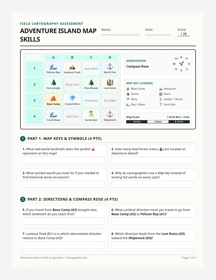
Ready, Detectives? It is time to explore Adventure Island!
Take out your field worksheet. You will use your map key, compass directions, scale bar calculations, and coordinate grid to crack every navigation challenge.
Identify all map symbols
Navigate cardinal directions
Calculate real distances with scale
Plot & locate alphanumeric points
Cartography Field Assignment Good luck on your expedition! →
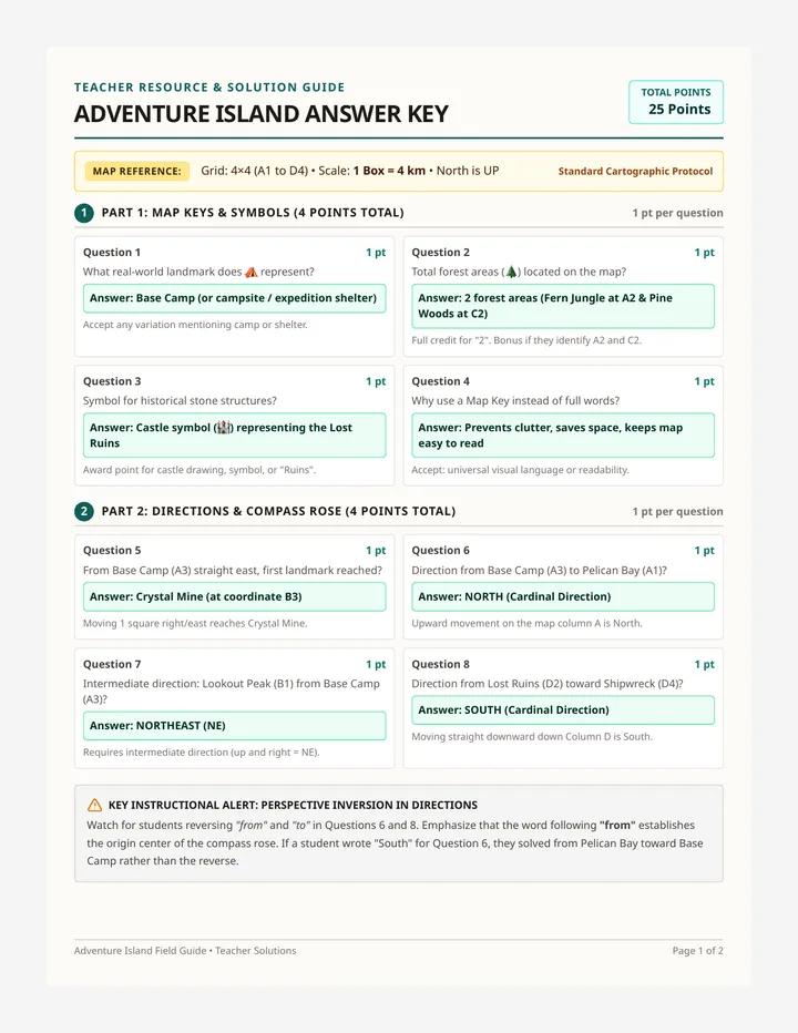
Adventure Island Answer Key
Teacher Resource & Solution Guide
ADVENTURE ISLAND ANSWER KEY
Total Points
25 Points
Map Reference: Grid: 4×4 (A1 to D4) • Scale: 1 Box = 4 km • North is UP
Standard Cartographic Protocol
1
Part 1: Map Keys & Symbols (4 Points Total)
1 pt per question
Question 1 1 pt
What real-world landmark does ⛺ represent?
Answer: Base Camp (or campsite / expedition shelter)
Accept any variation mentioning camp or shelter.
Question 2 1 pt
Total forest areas (🌲) located on the map?
Answer: 2 forest areas (Fern Jungle at A2 & Pine Woods at C2)
Full credit for "2". Bonus if they identify A2 and C2.
Question 3 1 pt
Symbol for historical stone structures?
Answer: Castle symbol (🏰) representing the Lost Ruins
Award point for castle drawing, symbol, or "Ruins".
Question 4 1 pt
Why use a Map Key instead of full words?
Answer: Prevents clutter, saves space, keeps map easy to read
Accept: universal visual language or readability.
2
Part 2: Directions & Compass Rose (4 Points Total)
1 pt per question
Question 5 1 pt
From Base Camp (A3) straight east, first landmark reached?
Answer: Crystal Mine (at coordinate B3)
Moving 1 square right/east reaches Crystal Mine.
Question 6 1 pt
Direction from Base Camp (A3) to Pelican Bay (A1)?
Answer: NORTH (Cardinal Direction)
Upward movement on the map column A is North.
Question 7 1 pt
Intermediate direction: Lookout Peak (B1) from Base Camp (A3)?
Answer: NORTHEAST (NE)
Requires intermediate direction (up and right = NE).
Question 8 1 pt
Direction from Lost Ruins (D2) toward Shipwreck (D4)?
Answer: SOUTH (Cardinal Direction)
Moving straight downward down Column D is South.
Key Instructional Alert: Perspective Inversion in Directions
Watch for students reversing "from" and "to" in Questions 6 and 8. Emphasize that the word following "from" establishes the origin center of the compass rose. If a student wrote "South" for Question 6, they solved from Pelican Bay toward Base Camp rather than the reverse.
Adventure Island Field Guide • Teacher Solutions Page 1 of 2