Continental Connection Slides World Geography Unit Collaborative Mapping Project
Continental Connection
Designing and assembling a massive, grid-aligned physical world map tile by tile.
Group Cartography Guilds
Prepare your coordinates and scaling tools.
The Mapping Quest
01 / The Mission
Earth's landforms define our global environment. Mountains isolate regions, rivers connect resource basins, and oceans link continents together.
Our Class Objective:
To combine individual regional quadrants into a huge 5-foot by 8-foot Physical World Map with flawless matching margins, coastal alignments, and scale.
Alignment Parameters
Mathematical Grid: Uniform 15-degree lines of latitude/longitude.Coastal Connection: Water borders must align perfectly at page edges.Unified Topography Key: Universal visual symbols for land elevations.
Unit: World Physical Geography Mathematical Cartography
Cartography Guilds
02 / Roles
Chief Geographer
Ensures absolute grid accuracy. Responsible for aligning latitude/longitude grid intersections and coordinating border connections with neighboring groups.
GRID MASTER
Physical Topographer
Researches and draws regional terrain elevations: mountain chains (Andes, Rockies, Himalayas), plateau basins, valleys, and dry desert plains.
TERRAIN DETAILED
Chief Hydrographer
Traces major global marine and river channels (Amazon, Nile, Mississippi, Yangtze). Coordinates coastlines and estuaries crossing sheet lines.
WATERWAYS MASTER
Key & Scale Master
Creates the map keys/legends, accurate distance graphic bar scales, standard coloring symbols, and drafts the quadrant compass rose.
SYMBOLS & SCALING
Collaboration forms our complete world view. Define role assignments today.
Anatomy of a Map Tile
03 / Key Constraints
To fit seamlessly, your individual quadrant must adhere to 4 strict mathematical mapping constraints:
1. Coordinate Boundaries
Label and mark precise degrees on all margins at 15-degree increments.
2. Exact Scale & Ratio
Design a distance scale reflecting modern metric and imperial equivalents.
3. Standard Palette
Use agreed physical coloring rules: blue for depths, brown for peaks, green for lowlands.
4. Overlay Testing
Physically compare edges with adjacent guilds to match flow lines.
Interface Calibration Diagram
Join Alignment Margins
Leave exactly 1 cm of flat paper border along non-bleed joining points.
Check neighbor grid boundaries before inking!
Map scale is uniform. Do not hand-sketch without a metric guide. Double check with neighbor coordinates.
The Global Grid Assignments
04 / Zone Sectors
Zone 1
The Americas
Continents: North & South AmericaCore Focus: Rockies, Andes, Amazon River, Mississippi River Basin, Caribbean Sea.
Connects East to Europe / Africa
Zone 2
Afro-Eurasia (West)
Continents: Europe & AfricaCore Focus: Alps, Sahara Desert, Nile, Congo, and Niger Rivers, Mediterranean Sea, Atlantic Basin.
Connects West to Americas, East to Asia
Zone 3
Asia & Oceania
Continents: Asia & AustraliaCore Focus: Himalayas, Gobi Desert, Outback Plains, Yangtze & Indus Rivers, Pacific Island Archipelagos.
Connects West to Europe / Africa
Oceans tie our physical world sections together. Coordinate ocean currents & pathways with your adjacent zones.
Critical Global Features
05 / Physical Targets
Our master map focuses entirely on earth's geographic features. You must locate, shape, and label physical formations precisely.
Elevations
Use brown gradient lines or relief triangles to display peak elevation heights.
Hydrology
Trace river basins from headwaters to oceans with accurate line widths.
Required Physical Targets
Zone Required Major Landforms The Americas Rockies, Andes, Amazon Basin, Mississippi, Great Lakes Europe & Africa Alps, Sahara Desert, Nile, Congo, Mediterranean Basin Asia & Oceania Himalayas, Gobi, Great Sandy Desert, Yangtze, Indus Basin
Verify absolute geographic placement on the global coordinate framework. Double-check with neighbors.
Project Launch Sequence
06 / Next Steps
I
Form Guilds
Form groups of 4. Select roles, select your coordinate zone, and record your details on your planning worksheet.
II
Research Data
Analyze coordinates of geographic features. Perform border handshakes with neighboring guilds to match coastal borders.
III
Pencil & Ink
Sketch lines of longitude/latitude. Draw shorelines and topography. Standardize mapping symbols, color and ink.
Mapmakers, begin your cartography quest!
World Cartographers Guild
Continental Connection Teacher Guide Teacher Lesson Manual
Continental Connection
PHYSICAL GEOGRAPHY
Project Framework & Objectives
The Continental Connection Project is a collaborative, tactile world geography task. Students form specialized Cartography Guilds of 4 to design a physical, coordinate-aligned tile representing a designated global quadrant. The final master map is physically assembled on the classroom wall, showcasing earth's grand mountain ranges, rivers, deserts, and major seas.
Technical Grid Specifications
To ensure individual tiles connect seamlessly without overlapping landmasses:
Base Grid Interval: 15 degrees spacingConnector Bleed: 1 cm white marginGlobal Projection: Mercator Style GridMap Sections: 12 connected sheetsAssembled Size: ~5 x 8 feetStandard Metric Scale: 1:1,500,000
Project Timeline (5 Days)
Day 1
Guild Setup & Regional Assignment
Group students, assign roles, distribute grid sheets and project criteria slides.
Day 2
Geodata Compilation & Handshakes
Guilds research coordinates of landforms and meet with neighbors to align coastline exits.
Day 3
Drafting Coastlines & Terrain
Apply coordinates, outline oceans/seas, double check adjacent grid joins with pencils.
Day 4
Topography detailing & Keys
Apply elevation shading, draw custom map keys, compass roses, and complete color rendering.
Day 5
Grand Assembly & Analytics
Assemble the master wall map. Individual student geographer reflection submission.
Printing & Materials Checklist:
Print the grid templates on thick 11" x 17" cardstock if possible, or standard US Letter cardstock. Gather colored pencils, fine-tip pigment liners, masking tape for the backing, and heavy-duty rulers.
© Continental Connection Project Page 1 of 2
Teacher Lesson Manual
Project Assessment Rubric
RUBRIC
Assessment Guidelines
This rubric evaluates rigorous cartographic skills, coordinate layout precision, accurate depiction of major global water and mountain systems, clean map key structures, and cohesive guild collaboration.
Category Excellent (4 pts)
Continental Connection Student Handbook Student Cartography Guide
Continental Connection
Name: _______________________
Date: ________________________
Your Mapping Mission
Welcome to the World Cartography Guild! Your group is responsible for drafting a complete physical segment of our global map. Your final map tile must line up perfectly with adjacent guilds' tiles to form a massive Physical World Map on the classroom wall.
Guild Profile & Member Assignments
Assigned Map Zone (Circle One): Zone 1 (Americas) | Zone 2 (Europe/Africa) | Zone 3 (Asia/Oceania)
🧭 Chief Geographer: _________________
🏔️ Physical Topographer: ____________
💧 Chief Hydrographer: ________________
📜 Key & Scale Master: _________________
Cartographic Quality Standards
Your mapping tile must include all of the following specifications to receive full credit.
Aligned Coordinates: Spaced strictly at 15-degree increments.
Standard Directions: Cardinal & ordinal points on your compass.
Physical Key: Neatly defined color symbols for elevation.
Water Flows: Rivers starting at high altitudes flowing to the seas.
Mountain Shading: Peak shapes colored in brown gradients.
Sea Boundaries: Ocean coastlines connecting accurately to neighbors.
Distance Scale: A metric graphic bar scale representing 1:1,500,000.
Edge Connection: A perfect boundary overlap handchecked with neighbors.
Step-by-Step Cartography Workflow
Step 1: Border Handshake. Find the guilds mapping zones adjacent to yours. Coordinate the exact latitude and longitude degrees where coastlines or rivers transition between your sheets.
Step 2: Trace Shorelines. Lightly sketch major coastlines, peninsulas, and seas first. Lay your sheets side-by-side with neighbor guilds to verify a smooth, continuous flow.
Step 3: Elevate and Drain. Place physical ranges (e.g. Rockies, Alps, Himalayas) and drain major river networks downwards from peaks towards ocean basins.
Step 4: Legend & Ink. Complete your map keys/legends and scale rulers. Carefully outline lines in ink, color physical landforms, and finalize.
© Continental Connection Project Page 1 of 2
Student Cartography Guide
Landmark Directory & Journal
Continental Connection Planning Sheet Research & Planning Organizer
Physical Terrain Registry
Names: _______________________
Date: ________________________
Terrain Registry Instructions
Before applying colored ink to poster sheets, your guild must gather raw coordinate data. Locate the approximate latitude and longitude ranges, natural flow paths, elevations, and visual symbols for the major landmarks in your assigned global zone.
Core Landform Coordinate Directory
Landform Name Latitude Range Longitude Range Visual Shading Standard Major River 1: (e.g. Amazon, Nile, Indus) Sinuous blue line... Major River 2: (e.g. Mississippi, Yangtze) Mountain Range: (e.g. Andes, Alps, Rockies) Penciled brown ridges... Arid Desert / Plain: (e.g. Sahara, Gobi, Outback) Stippled yellow/sand... Adjacent Ocean / Sea: (e.g. Pacific, Red, Atlantic) Solid blue depths...
Terrain & Water Flow Concept Draft
How do the natural elevations of your zone dictate the path of your rivers? Draw a quick diagram illustrating the high mountain springs flowing down to oceanic bays.
[ Draft Your Topography Flows and Elevation Slopes Here ]
© Continental Connection Project Page 1 of 2
Research & Planning Organizer
Boundary Intersect
Guild Name: _________________
Continent Bounding & High Points
Record coordinates for the high points of your assigned continents. Research and record the exact location of the highest peak in your quadrant.
Primary Continent Profile
Continent: _________________
Estimated Area: _____________
Primary Hemispheres: ________
Highest Elevation Peak
Peak Name: _________________
Latitude: _________________
Longitude: ________________
Sheet Border Coordination Log
Coordinate with adjacent guilds. Confirm who is to your West and East. Agree on the precise coordinate lines where oceans, islands, or rivers exit your page.
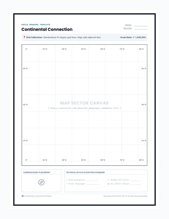
Continental Connection Grid Templates Guild Drawing Template
Continental Connection
Zone: _________
Guild: _________
📍 Grid Calibration: Standardized 15-degree grid lines. Align with adjacent tiles. Scale Ratio: 1 : 1,500,000
0° 15°W 30°W 45°W 60°W 75°W 90°W
MAP SECTOR CANVAS
[ Pencil coastlines and physical geography landmarks here ]
0° 15°W 30°W 45°W 60°W 75°W 90°W
45°N 30°N 15°N
45°N 30°N 15°N
Compass Rose Placement
Physical Keys & Elevation Standard
⏶ Peak Elevation: __________
☉ Global Port/City: _________
≈ River Drainage: ___________
▰ Dry Desert Plain: _________
© Continental Connection Project Standard Grid Sheet (11x17 format recommended)