Grid Quest Worksheet Atlas Adventurers • Day 1
Grid Quest Explorer
🌍 Hemispheric Overview
Student Name:
Date:
Class Period:
Explorer's Briefing: Defining the East
Earth is divided into hemispheres (literally "half-spheres") using imaginary reference lines. The Equator divides the planet into the Northern and Southern Hemispheres, while the Prime Meridian (0° longitude) and the 180th Meridian divide it into the Eastern and Western Hemispheres.
The Eastern Hemisphere —often called the "Old World"—contains Europe, Asia, Africa, and Australia, along with the Indian Ocean and parts of the Atlantic, Pacific, and Southern Oceans. To navigate this vast half of the globe, geographers use a grid system of latitude (lines running east-west, measuring north-south) and longitude (lines running north-south, measuring east-west). Understanding coordinates allows explorers to pinpoint any location, from the heights of the Himalayas to the vast expanses of the Sahara.
Part I: Coordinate Map Navigation
Analyze the simplified coordinate grid of the Eastern Hemisphere below. Use the grid lines of latitude and longitude to identify the geographic landmarks labeled A through E .
LAT / LONG
0° (P.M.)
30° E
60° E
90° E
120° E
150° E
60° N
Scandinavia
[ A ] Urals
Siberia
Siberia
Okhotsk
Bering Sea
30° N
[ B ] Sahara
Arabia
Indus V.
[ C ] Himalaya
Yangtze
Tokyo
0° (Equator)
Atlantic
Congo R.
East Africa
[ D ] Indian Oc.
Sumatra
Pacific
30° S
Atlantic
Kalahari
Indian Oc.
Indian Oc.
[ E ] Outback
Tasman Sea
Unit: Eastern Hemisphere Prep Packet Turn page over to complete questions. Page 1 of 2
Atlas Adventurers • Day 1
Grid Quest: Response Sheet
Name: ____________________________
A Coordinate Analysis
Refer back to the grid map on Page 1. Match each landmark letter with its exact latitude and longitude coordinates.
1. Urals (Landmark A):
2. Sahara Desert (Landmark B):
3. Himalayas (Landmark C):
4. Indian Ocean (Landmark D):
5. Australian Outback (Landmark E):
B Key Concept Comprehension
1. Explain the difference between lines of latitude and lines of longitude in your own words.
2. Which lines are the main reference boundaries that split Earth into Eastern and Western Hemispheres?
C The Lost Explorer's Journal
Scenario: You are an explorer in the year 1888. Your vessel is currently located at 0° (Equator) and 60° E longitude .
Look at the grid map. Where are you? Describe your immediate surrounding environment (e.g., land or water) and write a short, 2-3 sentence entry explaining your next navigation direction to reach the continent of Africa.
Unit: Eastern Hemisphere Prep Packet Complete all parts thoroughly before submitting. Page 2 of 2
Grid Quest Teacher Guide Atlas Adventurers • Substitute Teacher Key
Grid Quest Answer Key
🔑 Answer Key • Day 1
Substitute Grading & Pacing Tips:
This is an independent packet designed to take 45–50 minutes . Students should complete Page 1 reading and grid practice first, then flip to Page 2. Grade for completeness and reasonable geographical accuracy.
Part A: Coordinate Analysis Solutions
1. Urals (Landmark A): 60° N, 30° E
2. Sahara Desert (Landmark B): 30° N, 0°
3. Himalayas (Landmark C): 30° N, 90° E
4. Indian Ocean (Landmark D): 0° (Equator), 90° E
5. Australian Outback (Landmark E): 30° S, 120° E
Part B: Key Concept Comprehension (Sample Answers)
1. Difference between latitude and longitude:
"Lines of latitude run horizontally (east-west) and measure how far north or south a place is from the Equator. Lines of longitude run vertically (north-south) and measure how far east or west a place is from the Prime Meridian."
2. Main reference boundaries:
"The Prime Meridian (0° longitude) and the 180th Meridian are the primary vertical boundaries that split Earth into Eastern and Western Hemispheres."
Part C: The Lost Explorer's Journal (Sample Answer)
Where are you? Describe surroundings & next directional move:
"My coordinates (0° Equator, 60° E longitude) put me directly in the Indian Ocean, meaning I am surrounded by water on all sides. To reach the continent of Africa, our ship must navigate west toward 30° E longitude, crossing toward the East African coast."
📋 Sub Lesson Management Tip:
If students finish early, challenge them to list three independent countries in Europe or Africa that lie directly on the Prime Meridian (0° longitude) using their classroom textbook or an atlas if available. (Examples: UK, France, Spain, Algeria, Mali).
Unit: Eastern Hemisphere Substitute Sequence Confident grading keys for sixth grade geography. Page 1 of 1
River Kingdoms Worksheet Atlas Adventurers • Day 2
River Kingdoms
🌊 Ancient Civilizations
Student Name:
Date:
Class Period:
Civilization’s Spark: Floods and Silt
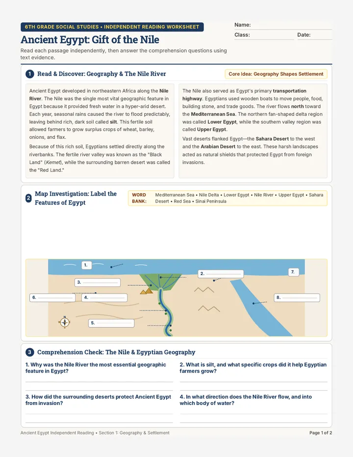
The earliest complex societies in the Eastern Hemisphere arose in wide, flat river valleys where fresh water was abundant. Two of the most famous examples are Mesopotamia (located between the Tigris and Euphrates Rivers in modern-day Iraq) and Ancient Egypt (located along the Nile River in northeastern Africa). Both of these regions were surrounded by harsh, arid deserts, meaning that the survival of their people depended entirely on the life-giving rivers.
Each year, seasonal melting snow and rainfall upstream caused these rivers to overflow. When the floodwaters receded, they left behind a rich, dark mud called silt . Silt acted as a natural fertilizer, making the sandy soil incredibly fertile and perfect for agriculture. However, managing this water was a monumental challenge. If a flood was too small, crops withered; if it was too violent, cities were washed away. To control the water, both societies developed sophisticated engineering systems: irrigation canals , dikes to hold back floods, and basins to store water for the dry season.
Part I: Regional Comparison Chart
Study the geographical differences between these two foundational river kingdoms below.
Mesopotamia Tigris & Euphrates
• Flooding: Highly unpredictable and violent, requiring massive dike building.
• Geography: Open plains, highly vulnerable to foreign invasion; few natural barriers.
• Writing System: Cuneiform , wedge-shaped symbols pressed into clay tablets using a stylus.
Cuneiform Concept Sample: 🌾 𐎍 𐎏
Ancient Egypt The Nile River
• Flooding: Predictable, regular flood patterns ("the gift of the Nile") celebrated by citizens.
• Geography: Protected by natural barriers (deserts to east/west, rapids/cataracts to south).
• Writing System: Hieroglyphics , complex pictorial symbols written on papyrus paper.
Hieroglyphic Concept Sample: 𓉔 𓆓 𓅱
Unit: Eastern Hemisphere Prep Packet Turn page over to complete questions. Page 1 of 2
Atlas Adventurers • Day 2
River Kingdoms: Response Sheet
Name: ____________________________
River Kingdoms Teacher Guide Atlas Adventurers • Substitute Teacher Key
River Kingdoms Answer Key
🔑 Answer Key • Day 2
Substitute Grading & Pacing Tips:
This packet deals with agricultural engineering and scribal writing. Estimated completion: 45 minutes . Accept drawing designs that represent logical farming or water management concepts in Part C.
Part A: Flooding and Adaptations (Sample Answers)
1. Why flooding was a blessing and a curse in Mesopotamia & adaptations:
"Flooding was a blessing because it left behind highly fertile silt for farming, but a curse because it was violent and unpredictable, often destroying homes. To control this, Mesopotamians built dikes to block river surges and dug irrigation canals to route water safely to distant dry crops."
2. How Egypt’s geography protected it compared to Mesopotamia:
"Egypt was protected by massive natural barriers: vast deserts on both sides (the Sahara and Eastern Deserts) and rough river rapids (cataracts) to the south. Mesopotamia, situated on open plains, had very few natural barriers and was constantly vulnerable to foreign invasions."
Part B: The Written Word Solutions
a. Wedge-shaped clay tablets: Cuneiform
b. Pictorial papyrus scrolls: Hieroglyphics
Why did agricultural civilizations require record-keeping systems? "As food surpluses grew, complex civilizations had to keep track of crop yields, grain storage records, trade transactions, and tax collections across many settlements."
Part C: Scribe Workshop Grading Criteria
• Visual Symbol: Award full points if the symbol is hand-drawn and represents an early agricultural concept (such as waves for "Flood", channels for "Irrigation", or wheat for "Crops").
• Written Explanation: Look for a logical link. For example: "I drew three wavy horizontal lines to represent the yearly Nile flood because water levels rose and submerged the banks."
📋 Sub Lesson Management Tip:
If students complete this early, have them turn the page over and write their first and last name using invented geometric pictographs representing the sounds of their name!
Unit: Eastern Hemisphere Substitute Sequence Confident grading keys for sixth grade geography. Page 1 of 1
Asian Cradles Worksheet Atlas Adventurers • Day 3
Asian Cradles
🌊 Indus & Yellow Rivers
Student Name:
Date:
Class Period:
Monsoons, Mud, and Mountains
In South and East Asia, two major river systems nurtured early societies under distinct geographic conditions. In the Indian subcontinent, the Indus River Valley Civilizations (Harappa and Mohenjo-Daro) flourished around 2500 BCE. They depended on the Indus River, fed by melting Himalayan snow, and seasonal winds called monsoons , which brought heavy summer rains. Harappan farmers adjusted to these monsoons to cultivate wheat, barley, and cotton.
Further east, Ancient China emerged along the Huang He (Yellow River). The river is named for its thick, yellow silt called loess , blown in from the Gobi Desert. While loess made the valley highly fertile, the Yellow River was also called "China's Sorrow" due to its catastrophic, unpredictable floods. Hemmed in by massive natural barriers—the Himalayas, Gobi Desert, and Pacific Ocean—Ancient China developed in relative isolation, viewing itself as the middle of the civilized world.
Part I: Engineering Marvels of the Ancient East
Review the architectural and environmental differences in how these two civilizations organized their cities and controlled their rivers.
Harappan Urban Grids Mohenjo-Daro
Harappan cities were planned with incredible precision. Unlike the organic, messy growth of Mesopotamia, Harappa and Mohenjo-Daro featured:
• Grid-planned streets intersecting at right angles.
• Uniform bricks baked in standardized kilns.
• An underground drainage system with drains from private homes running directly into street sewer lines.
Key Feature: Grid Street Alignment & Plumbing
China’s Water Control Huang He Valley
To defend against "China's Sorrow" (Huang He floods) and harness the loess soil, ancient Chinese dynastic leaders directed citizens to build:
• Massive earthen levees (dikes) to keep rivers in channels.
• Extensive irrigation ditches spreading the loess silt.
• High stone terraces for crop protection during surges.
Key Feature: Loess Levee & Terrace Engineering
Unit: Eastern Hemisphere Prep Packet Turn page over to complete questions. Page 1 of 2
Atlas Adventurers • Day 3
Asian Cradles: Response Sheet
Name: ____________________________
A Environmental Forces
Asian Cradles Teacher Guide Atlas Adventurers • Substitute Teacher Key
Asian Cradles Answer Key
🔑 Answer Key • Day 3
Substitute Grading & Pacing Tips:
This activity focuses on environmental geography (monsoons and silt) and early engineering. Pacing: 45 minutes . In Part C, grade the grid sketch for effort and correct labels rather than perfect artistry.
Part A: Environmental Forces (Sample Answers)
1. What is a "monsoon" and why was it crucial to Indus survival?
"A monsoon is a seasonal wind pattern that brings heavy rains in the summer. It was crucial because the Indus River Valley had dry winter climates; the summer monsoons provided the essential rainwater to grow massive crops of barley, wheat, and cotton."
2. Describe loess and why it made the Huang He valley productive:
"Loess is a fine, yellow silt blown from the Gobi Desert into the riverbed. Although the Huang He flooded catastrophically, the loess deposited by the floodwaters acted as an excellent, easy-to-dig fertilizer that made farming highly productive between flood cycles."
Part B: Urban Planning vs. Organic Expansion Solutions
Advanced engineering elements in Harappan homes (Any two): 1. Standardized kiln-baked bricks • 2. Private wells • 3. Underground drainage channels connected to toilet chutes
Contrast: How does a planned grid city differ from an unplanned one? "A planned grid city is organized beforehand with straight, wide roads intersecting at 90-degree angles, separating living quarters from municipal systems. Unplanned cities grow organically and chaotically, resulting in winding, narrow dirt alleys and poor sewage controls."
Part C: Harappan Grid Planner Grading Guidelines
• Required Elements: Verify the student sketched at least three perpendicular intersecting straight streets, drew two residential block squares, and included/labeled a water well or sewer drain channel.
• Classroom Observation: Look for labels such as "Main Sewer", "Brick Housing Block", or "Freshwater Well".
📋 Sub Lesson Management Tip:
If students complete this early, have them write down an imaginary news bulletin about "China's Sorrow" warning a village that the Huang He is rising, and what actions they must take!
Unit: Eastern Hemisphere Substitute Sequence Confident grading keys for sixth grade geography. Page 1 of 1
Silk Road Worksheet Atlas Adventurers • Day 4
The Silk Road
🐫 Trade & Exchange
Student Name:
Date:
Class Period:
Bridging East and West: The Overland Network
The Silk Road was not a single paved highway, but a massive 4,000-mile network of overland trade routes that connected East Asia with the Mediterranean world. Active for over a thousand years, it allowed major empires—such as the Han Dynasty in China and the Roman Empire in Europe—to exchange luxurious goods, rare resources, and powerful new technologies.
Traveling the Silk Road was incredibly dangerous. Caravans of camels and merchants had to cross two of the world's most brutal geographical obstacles: the Taklamakan Desert (whose name translates to "you go in, but you do not come out") and the freezing, high-altitude passes of the Pamir Mountains . To survive, traders traveled in large groups called caravans and relied on oasis towns —fertile spots in the desert fed by underground springs—to rest and restock water. This movement did more than trade physical goods; it facilitated cultural diffusion , spreading ideas, languages, and religions (like Buddhism) across continents.
Part I: Regional Exchange Ledger
Review the primary luxury goods and materials exchanged across the three major sectors of the Silk Road.
🇨🇳 East Asia (China) Origin of Silk
The Han Dynasty strictly guarded the secret of silk production, making Chinese silk a highly coveted status symbol in Europe.
🎁 Exported: Silk, Tea, Porcelain 📥 Imported: Horses, Glass, Gold
🐫 Central Oasis Towns The Middlemen
Oasis settlements (like Dunhuang and Samarkand) acted as trade hubs where merchants swapped goods, camels, and stories.
🎁 Exported: Jade, Rugs, Alfalfa 📥 Imported: Spices, Silk, Weapons
🇮🇹 Mediterranean (Rome) The Western Terminal
Rome craved eastern goods, paying in gold and exquisite blown glassware, which Chinese emperors highly prized.
🎁 Exported: Glassware, Gold, Olive Oil 📥 Imported: Silk, Spices, Paper
Unit: Eastern Hemisphere Prep Packet Turn page over to complete questions. Page 1 of 2
Atlas Adventurers • Day 4
The Silk Road: Response Sheet
Name: ____________________________
A Navigating Hazardous Landscapes
Refer to the reading text on Page 1 to explain how geography shaped the experiences of ancient traders.
1. What makes the Taklamakan Desert and the Pamir Mountains dangerous for camel caravans? Mention one specific threat for each.
Silk Road Teacher Guide Atlas Adventurers • Substitute Teacher Key
The Silk Road Answer Key
🔑 Answer Key • Day 4
Substitute Grading & Pacing Tips:
This topic involves long-distance trade mechanics, physical geography hazards, and cultural diffusion. Estimated completion: 45–50 minutes . Part C allows student choice; check that items chosen match the reading details.
Part A: Navigating Hazardous Landscapes (Sample Answers)
1. Why are the Taklamakan Desert and Pamir Mountains dangerous?
"The Taklamakan Desert is dangerous due to its extreme, dehydrating heat and sandstorms (the name means 'you go in, but do not come out'). The Pamir Mountains are dangerous due to freezing temperatures, narrow cliffside trails, and thin air at high altitudes."
2. What is an oasis, and why were they critical lifelines?
"An oasis is a fertile area in a desert supplied by underground spring water. They were critical lifelines because they were the only places where camel caravans could rest, refill water skins, trade for food, and escape deadly sandstorms."
Part B: Understanding Cultural Diffusion (Sample Answer)
How could a foreign merchant accidentally spread religious beliefs (like Buddhism)?
"While staying in oasis towns to trade goods, merchants spent nights in local hostels or markets talking to townspeople. Through these casual conversations about their home life and personal values, they naturally shared their beliefs, stories of the Buddha, and religious scrolls, which locals then adopted."
Part C: Caravan Packing List Solutions (Sample Choices)
• Sample Item 1 Choice (Silk): "Highly valuable in Central Asia/Rome because China guarded the secret of silk production, making it a rare, soft luxury that only royalty could afford."
• Sample Item 2 Choice (Porcelain or Tea): "Tea or Porcelain was unique to China and highly prized for ceremonies, dinnerware, and health qualities, commanding gold in exchange."
📋 Sub Lesson Management Tip:
If students complete this early, have them write an advertisement flyer designed to convince a Roman patrician to purchase a bolt of high-grade Chinese purple silk!
Unit: Eastern Hemisphere Substitute Sequence Confident grading keys for sixth grade geography. Page 1 of 1
Sand and Gold Worksheet Atlas Adventurers • Day 5
Sand and Gold
🐪 African Kingdoms
Student Name:
Date:
Class Period:
The Trans-Saharan Highway: Salt for Gold
The vast Sahara Desert covers much of northern Africa, acting as a natural geographic barrier. Yet, starting around 300 CE, the introduction of the Asian camel—the "ship of the desert"—revolutionized travel. Camels could carry heavy loads and travel up to ten days without fresh water. This enabled West African traders to establish active trans-Saharan trade routes , bridging Mediterranean ports with West Africa's savanna regions.
This trade network relied on the exchange of two highly prized resources: gold and salt . In the southern forest region of Wangara, gold mines were incredibly rich, but salt was extremely scarce. In the northern Sahara at Taghaza, salt blocks were mined directly from dried ancient seabeds, but gold was non-existent. Because human bodies lose vital salts through sweat in hot climates, and because salt was the only way to preserve meat in an era before refrigeration, West Africans traded their gold for salt—sometimes at an equal ounce-for-ounce value. The medieval Empire of Mali sat squarely in the middle of these trade routes, taxing all caravans that crossed their borders and building legendary wealthy cities like Timbuktu .
Part I: The Trans-Saharan Trade Axis
Study how gold, salt, and trade routes crossed paths in West Africa, transforming Mali's trade capitals into wealthy centers of learning.
🏜️ Northern Sahara Salt Origin (Taghaza)
Massive slabs of mineral salt are mined out of desert salt flats. Slabs are loaded onto camel caravans heading south.
🎁 Exported: Salt Blocks, Books 📥 Imported: Gold Dust, Ivory
🦁 Mali Empire Hub Commercial Capitals
Mali's kings protect routes and collect heavy customs taxes. Timbuktu becomes a world capital for books and universities.
🎁 Exported: Copper, Fabrics 📥 Imported: Gold & Salt (Taxed)
🌳 Southern Savanna Gold Origin (Wangara)
Deep forest miners dig out gold dust and nuggets. They rely on northern salt caravans to preserve their food and survive the heat.
🎁 Exported: Gold, Ivory, Kola Nuts 📥 Imported: Salt, Iron, Fabrics
Unit: Eastern Hemisphere Prep Packet Turn page over to complete questions. Page 1 of 2
Atlas Adventurers • Day 5
Sand and Gold: Response Sheet
Name: ____________________________
A Saharan Highway Economics
Answer the following questions based on the geographical trade patterns of northern and western Africa.
Sand and Gold Teacher Guide Atlas Adventurers • Substitute Teacher Key
Sand and Gold Answer Key
🔑 Answer Key • Day 5
Substitute Grading & Pacing Tips:
This final packet reviews the trans-Saharan gold-salt trade. Completion: 45 minutes . In Part C, award credit for any logical items sketched or written that relate to desert survival (water, shade, food).
Part A: Saharan Highway Economics (Sample Answers)
1. Why was salt considered just as valuable as gold to the forest-dwellers?
"First, biologically, humans lose massive amounts of salt through sweat in hot climates, and salt is necessary to survive. Second, practically, salt was the only way to preserve meat and food from spoiling in a tropical environment without refrigeration."
2. How did the introduction of Asian camels change the geography of trade?
"The introduction of camels transformed Saharan geography from an impassable wall into a trade highway. Camels could carry heavy goods and go up to ten days without fresh water, allowing traders to bypass waterless sandy wastes that had previously blocked communication."
Part B: The Commercial Crossroads (Sample Answer)
How did Mali grow wealthy? What economic strategy did they use?
"Mali grew wealthy by sitting squarely between the salt mines of the north and the gold mines of the south. Their core economic strategy was taxation: Mali’s kings collected heavy customs tariffs on every single load of salt, gold, and copper entering or leaving their empire."
Part C: Caravan Packing Blueprint Grading Guidelines
• Expected Student Work: Accept drawing sketches or bulleted text lists representing desert survival gear. Expected items:
• Waterskins (leather)
• Dried dates / salt-meat
• Tents / head-wraps
📋 Sub Lesson Management Tip:
If students complete this early, have them write down a hypothetical conversation between a salt miner from Taghaza and a gold miner from Wangara arguing about whose product is more valuable!
Unit: Eastern Hemisphere Substitute Sequence Confident grading keys for sixth grade geography. Page 1 of 1