Migration Routes Slides Lesson 1 • Field Expedition
Out of Africa
How Homo sapiens crossed continents, adapted to new climates, and peopled the Earth.
30-Minute Lesson 70,000 – 15,000 Years Ago
Warm-Up Question
Why would a group leave everything they know behind?
Push Factors
Problems that force people to leave: droughts, shrinking herds, or sudden cold spells.
Pull Factors
Opportunities that draw people in: fresh water, abundant game, and milder climates.
The Great Migration Timeline
~70,000 BCE
Leaving Africa
Small bands cross the Red Sea and Sinai into Southwest Asia.
~50,000 BCE
Asia & Europe
Groups follow coastlines to Australia and move north into Europe.
~15,000 BCE
The Americas
Ice Age sea levels expose Beringia, connecting Asia to North America.
How Did Early Humans Survive New Climates?
Controlled Fire: Provided warmth in freezing Ice Age regions and cooked new foods.
Tailored Clothing: Bone needles let bands sew animal hides for windproof protection.
Portable Shelters: Mammoth-bone and hide huts kept groups safe where caves were rare.
Field Log Activity (10 Min)
Complete Your Migration Field Log
Sort each migration clue into a Push Factor or Pull Factor .
Order the three major migration waves from earliest to latest.
Explain one adaptation that helped Homo sapiens survive outside Africa.
Migration Field Log Worksheet Dawn of Settlements • Lesson 1
Migration Field Log (Page 1 of 2)
Name: __________________________
Date: ___________________________
Part 1: Push or Pull?
Write PUSH (forcing people to leave) or PULL (drawing people to a new place) on each blank.
1. A long drought dries up local rivers and plants.
2. Rich coastal waters offer plenty of shellfish and fish.
3. Animal herds migrate north into greener grasslands.
4. Growing bands compete for limited wild food in one valley.
Part 2: Order the Migration Waves
Number these 4 regions (1, 2, 3, 4) from earliest to latest arrival by Homo sapiens .
The Americas (via Beringia)
Southwest Asia
Australia & Europe
Africa (Starting Point)
Part 3: Survival Adaptations
Choose two adaptations (fire, tailored clothing, or portable shelters). Explain how each helped Homo sapiens survive in a cold or unfamiliar environment.
Adaptation 1:
Adaptation 2:
Dawn of Settlements Unit Page 1 of 2
Dawn of Settlements • Lesson 1
Migration Exit Check (Page 2 of 2)
Name: __________________________
Date: ___________________________
Exit Check
Why was following coastlines a smart strategy for early migrants?
Dawn of Settlements Unit Page 2 of 2
Out of Africa Teacher Guide Teacher Guide & Answer Key • Lesson 1
Out of Africa (30 Minutes)
Objective: Migration Routes & Factors
30-Minute Pacing Plan
Time
Segment
Teacher Actions
0–5 min
Hook (Slide 2)
Ask students why people move today; bridge to Push vs. Pull factors.
5–15 min
Mini-Lesson (Slides 3–4)
Walk through the migration waves and 3 survival adaptations.
15–25 min
Field Log (Slide 5)
Students complete Parts 1–3 independently or in pairs.
25–30 min
Wrap-Up & Exit Check
Review answers together; collect Exit Check on coastal routes.
Differentiation & Common Misconceptions
Misconception: Early humans marched across continents with a destination in mind. Clarify that migration took tens of thousands of years, following food and water generation by generation.Support: Allow emerging writers to complete one adaptation in Part 3 in writing and sketch/label the second.
Answer Key: Migration Field Log
Part 1: Push or Pull?
1. PUSH (drought forces people to leave) | 2. PULL (abundant food draws people) | 3. PULL (following herds to greener land) | 4. PUSH (overcrowding/competition)
Part 2: Order the Migration Waves (4 Regions)
1 = Africa (Starting Point) | 2 = Southwest Asia (~70,000 BCE) | 3 = Australia & Europe (~50,000 BCE) | 4 = The Americas (~15,000 BCE)
Part 3 & Exit Check (Sample Responses)
Part 3 (any two): Fire gave warmth in freezing Ice Age climates and cooked new foods; tailored clothing sewn with bone needles blocked freezing wind; portable shelters protected bands where caves were scarce. Exit Check: Coastlines offered steady seafood, fresh water, and easier travel than mountains or deserts.
Paleolithic Life Slides Lesson 2 • Field Expedition
Paleolithic Life Recap
Before cities and farms, how did humans survive for over two million years?
30-Minute Lesson Old Stone Age (to ~10,000 BCE)
Quick Brainstorm
If you had to carry everything you owned on your back, what would you keep?
Paleolithic people were nomads —they moved constantly to follow wild animals and seasonal plants. Every tool had to be light and useful.
Four Pillars of the Old Stone Age
1. Hunter-Gatherers
Men and women worked together to hunt game, fish, and gather berries, nuts, and roots.
2. Small Bands
Groups of 20–50 people traveled together because the land could not feed huge crowds.
3. Stone & Bone Tools
Flint hand axes, spear points, scrapers, and bone needles made hunting and sewing possible.
4. Cave Art & Culture
Paintings at Lascaux and Chauvet show deep respect for animals and shared beliefs.
Why Was Paleolithic Life Risky?
Unpredictable Food: No farms meant one bad winter or dry season could cause starvation.
Constant Travel: Moving camp often made caring for the very young or elderly difficult.
Recap Check (10 Min)
Complete the Hunter-Gatherer Recap
Match each Paleolithic tool or trait to how it helped bands survive.
Answer the multiple-choice recap questions.
Predict: What one discovery could allow small bands to stop moving?
Hunter Gatherer Recap Worksheet Dawn of Settlements • Lesson 2
Hunter-Gatherer Recap
Name: __________________________
Date: ___________________________
Part 1: Survival Toolkit Match
Write the letter of the matching survival purpose next to each Paleolithic feature.
1. Flint hand axe
2. Nomadic bands (20–50)
3. Controlled fire
4. Cave paintings
A. Cooked meat, scared predators, and gave warmth.
B. Cut meat, shaped wood, and scraped hides.
C. Shared beliefs, stories, and respect for animals.
D. Kept groups small enough to move and find food.
Part 2: Paleolithic Check
5. Why did Paleolithic people rarely build permanent stone houses?
A. They preferred living in trees
B. They had to follow migrating herds
C. Rocks did not exist yet
D. Laws banned permanent homes
6. Which was the biggest daily risk for a Paleolithic band?
A. Running out of wild food in winter
B. Crowded city traffic
C. Paying taxes to a king
D. Overproducing too much grain
Part 3: Looking Ahead
Imagine a band discovers how to grow their own food in one spot. How would their daily life change?
Dawn of Settlements Unit Paleolithic Era Recap
Paleolithic Recap Teacher Guide Teacher Guide & Answer Key • Lesson 2
Paleolithic Life Recap (30 Minutes)
Objective: Hunter-Gatherer Survival
30-Minute Pacing Plan
Time
Segment
Teacher Actions
0–5 min
Hook (Slide 2)
Quick turn-and-talk: what fits in one backpack? Connect to nomadism.
5–15 min
Recap (Slides 3–4)
Review the 4 pillars and why Paleolithic survival was unpredictable.
15–25 min
Worksheet (Slide 5)
Students complete Parts 1–3 on the Hunter-Gatherer Recap sheet.
25–30 min
Share & Bridge
Share Part 3 predictions to tee up Lesson 3 (Neolithic Revolution).
Instructional Notes & Differentiation
Key Contrast: Emphasize that Paleolithic = mobile, small bands, wild food . This sets up tomorrow's contrast with Neolithic settlements.Support: Read Part 1 options aloud for developing readers before independent work.
Answer Key: Hunter-Gatherer Recap
Part 1: Survival Toolkit Match
1. B (Flint hand axe) | 2. D (Nomadic bands) | 3. A (Controlled fire) | 4. C (Cave paintings)
Part 2: Paleolithic Check
5. B (They had to follow migrating herds) | 6. A (Running out of wild food in winter)
Part 3: Looking Ahead (Sample Response)
People could stay in one place, build sturdy permanent homes, store extra food for winter, and live in larger communities.
Neolithic Revolution Slides Lesson 3 • Field Expedition
The Neolithic Spark
How learning to farm and domesticate animals sparked the biggest shift in human history.
30-Minute Lesson New Stone Age (~10,000 – 3,000 BCE)
The Neolithic Revolution (~10,000 BCE)
As Ice Age glaciers melted, warmer climates let wild wheat and barley thrive. People began planting seeds and taming animals instead of only chasing food.
Plant Domestication
Saving the best seeds from wheat, barley, lentils, and peas to grow reliable crops.
Animal Domestication
Raising sheep, goats, pigs, and cattle for steady meat, milk, wool, and labor.
The Farming Chain Reaction
Step 1
Food Surplus
Farms produced more grain than a family needed for one day, creating stored reserves.
Step 2
Permanent Homes
Farmers stayed put to guard fields and storehouses, building mudbrick villages.
Step 3
Specialization
With extra food, some villagers became potters, weavers, toolmakers, and builders.
Old Stone Age vs. New Stone Age
Paleolithic (Old)
Nomadic lifestyle
Hunted & gathered wild food
Small bands (20–50)
Temporary camps or caves
Neolithic (New)
Sedentary (settled) lifestyle
Farmed crops & herded animals
Growing villages (hundreds+)
Permanent mudbrick houses
Comparison Lab (10 Min)
Complete Paleo vs. Neo Comparison
Fill in the comparison chart for food, shelter, and community size.
Trace how a food surplus leads to job specialization .
Write one advantage and one new challenge of settled village life.
Paleo vs Neo Worksheet Dawn of Settlements • Lesson 3
Paleo vs. Neo Comparison
Name: __________________________
Date: ___________________________
Part 1: Compare the Two Eras
Complete the chart below to show how daily life changed during the Neolithic Revolution.
Category
Paleolithic Era (Old)
Neolithic Era (New)
Food Source
Shelter
Community Size
Part 2: Explain the Chain Reaction
In your own words, explain how having a food surplus made job specialization (like potters and weavers) possible.
Part 3: Settled Life Trade-Offs
Write one major benefit and one new challenge of living in a permanent farming village.
Benefit of Settled Life:
New Challenge of Settled Life:
Dawn of Settlements Unit The Neolithic Revolution
Neolithic Spark Teacher Guide Teacher Guide & Answer Key • Lesson 3
The Neolithic Spark (30 Minutes)
Objective: Farming & Surplus
30-Minute Pacing Plan
Time
Segment
Teacher Actions
0–5 min
Intro (Slide 2)
Define domestication and connect to warmer post-Ice Age climate.
5–15 min
Mini-Lesson (Slides 3–4)
Trace Surplus → Permanent Homes → Specialization; compare Paleo vs. Neo.
15–25 min
Comparison Lab (Slide 5)
Students complete the Paleo vs. Neo Comparison worksheet.
25–30 min
Debrief
Discuss trade-offs (e.g., disease, defending stored grain) to preview Jericho.
Differentiation & Key Vocabulary
Key Terms: Neolithic Revolution , domestication , surplus , specialization .Support: Provide a word bank on the board (hunting, farming, caves, mudbrick, 20–50, hundreds ) for Part 1.
Answer Key: Paleo vs. Neo Comparison
Part 1: Compare the Two Eras
Food: Paleo = hunted & gathered wild food | Neo = farmed crops & raised domesticated animals.Shelter: Paleo = temporary camps/caves | Neo = permanent mudbrick houses.Size: Paleo = small nomadic bands (20–50) | Neo = settled villages (hundreds+).
Part 2: Chain Reaction (Sample)
When farmers grew extra food (a surplus), not everyone had to spend all day finding food. Some people could focus on other jobs like making pottery, weaving cloth, or building homes.
Part 3: Trade-Offs (Sample)
Benefit: Reliable food supply and sturdy shelter. Challenge: Crop failure/drought, disease spreading in crowded villages, or raiders stealing stored grain.
Jericho Case Study Slides Lesson 4 • Settlement Case Study
Jericho Deep Dive
Inside one of the world's oldest walled farming towns—founded around 9000 BCE.
30-Minute Lesson Jordan River Valley (West Bank)
Location & Survival
An Oasis in a Dry Valley
Natural Spring
Jericho grew beside the Ein es-Sultan spring, providing fresh water year-round in a dry desert valley.
Early Farming
With steady water and flat soil, ~2,000–3,000 villagers grew wheat, barley, figs, and herded goats.
Engineering Feat: The Wall & Tower
12-Foot Stone Wall
Built around 8000 BCE—possibly to protect stored grain from raiders or block seasonal mudslides and floods.
28-Foot Stone Tower
Featured an internal stone staircase! Building it required organized teamwork and leadership.
Daily Life in Neolithic Jericho
Mudbrick Homes
Round (later rectangular) sun-dried mudbrick houses with plastered floors kept families cool.
Long-Distance Trade
Archaeologists found Dead Sea salt, Anatolian obsidian, and Red Sea shells—proof of early trade!
Archaeologist Dossier (10 Min)
Complete the Jericho Case File
Identify the geographic feature that made Jericho possible.
Analyze two theories for why Jericho built its massive stone wall.
Explain what Jericho's tower and trade goods reveal about its society.
Jericho Dossier Worksheet Dawn of Settlements • Lesson 4
Jericho Archaeological Dossier
Name: __________________________
Date: ___________________________
Age: ~9000 BCE
Population: ~2,000–3,000
Key Feature: Ein es-Sultan Spring
Part 1: Location & Survival
Jericho was built in a dry, hot valley. Why did thousands of people settle in this exact spot?
Part 2: Mystery of the Stone Wall & Tower
Archaeologists debate why Jericho's villagers built a 12-foot stone wall and a 28-foot tower. Write two different theories below.
Theory 1 (Protection from People):
Theory 2 (Protection from Nature):
Part 3: Reading the Artifacts
Inside Jericho, archaeologists found obsidian (volcanic glass) from hundreds of miles away and a 28-foot tower with an inside staircase. What do these two clues prove about Jericho's people?
Dawn of Settlements Unit Case Study: Jericho
Jericho Teacher Guide Teacher Guide & Answer Key • Lesson 4
Jericho Deep Dive (30 Minutes)
Objective: Early Settlement Case Study
30-Minute Pacing Plan
Time
Segment
Teacher Actions
0–5 min
Hook (Slide 2)
Ask: "How could 2,000 farmers live in a desert?" Reveal the oasis spring.
5–15 min
Case Study (Slides 3–4)
Examine the 12-ft wall, 28-ft tower, mudbrick homes, and trade goods.
15–25 min
Dossier (Slide 5)
Students complete Parts 1–3 on the Jericho Archaeological Dossier.
25–30 min
Debrief
Vote on the wall theory (raiders vs. floods) and preview Catalhoyuk.
Historical Note & Differentiation
Archaeology Update: Many modern archaeologists think Jericho's wall also protected against flash floods and mudslides from nearby hills, not only human raiders.Support: Pair students for Part 2 so they can brainstorm both theories verbally before writing.
Answer Key: Jericho Archaeological Dossier
Part 1: Location & Survival
Jericho sat beside a natural oasis spring (Ein es-Sultan) that gave villagers steady fresh water for drinking and farming in a dry valley.
Part 2: Mystery of the Stone Wall & Tower
Theory 1 (People): To defend stored grain and valuable goods from nomadic raiders. Theory 2 (Nature): To block seasonal floods and mudslides from washing away the village.
Part 3: Reading the Artifacts
Obsidian proves Jericho traded with distant regions. The 28-foot tower proves villagers had organized leadership, teamwork, and extra time/food (surplus) to build large public structures.
Midpoint Review Study Guide Dawn of Settlements • Lessons 1–4
Midpoint Study Guide
Name: __________________________
Date: ___________________________
1. Out of Africa (~70,000–15,000 BCE)
Push Factors: Droughts, scarce food, competition.Pull Factors: Fresh water, coastlines, migrating herds.Wave Order: SW Asia → Australia & Europe → Americas (Beringia).Adaptations: Fire, tailored hide clothing, portable shelters.
2. Paleolithic Era (Old Stone Age)
Nomads: Moved constantly to follow wild plants and herds.Small Bands: 20–50 people so the land could feed everyone.Tools: Flint hand axes, spears, scrapers, bone needles.Risks: Unpredictable food in winter or dry seasons.
3. Neolithic Revolution (~10,000 BCE)
Domestication: Taming plants (wheat/barley) and animals (sheep/goats).Food Surplus: Growing extra grain to store for later.Chain Reaction: Surplus → Permanent homes → Job specialization.New Challenges: Defending stored food, disease in crowded towns.
4. Jericho Case Study (~9000 BCE)
Oasis Spring: Ein es-Sultan spring gave water in a dry valley.12-ft Stone Wall: Built against raiders or seasonal flash floods.28-ft Tower: Proves teamwork and organized leadership.Trade: Dead Sea salt, Red Sea shells, Anatolian obsidian.
Must-Know Vocabulary
Nomad: Person who moves from place to place for food.
Domestication: Taming plants or animals for human use.
Surplus: Extra food stored beyond immediate daily needs.
Specialization: Focusing on one job (potter, weaver, builder).
Quick Self-Check (Practice Before the Quiz)
1. Give one example of a push factor and one example of a pull factor in early human migration.
2. How did a food surplus lead to job specialization ?
Dawn of Settlements Unit Midpoint Review (Lessons 1–4)
Midpoint Quiz Dawn of Settlements • Lessons 1–4
Midpoint Quiz
Name: __________________________
Date: ___________________________
Part 1: Multiple Choice (2 pts each)
1. Which is an example of a pull factor that drew Homo sapiens into new regions?
A. A severe drought drying up local springs
B. Coastlines rich with shellfish and fresh water
C. Overcrowding in a small valley
D. Freezing Ice Age blizzards
2. Why did Paleolithic hunter-gatherers travel in small bands of 20–50 people?
A. Wild plants and game could not feed huge crowds
B. They had to guard large stone grain warehouses
C. Kings limited the size of every village
D. They only traveled by large wooden ships
3. What major change defines the start of the Neolithic Revolution?
A. Discovering how to make flint hand axes
B. Painting animals on cave walls
C. Farming crops and domesticating animals
D. Crossing Beringia into North America
4. What natural feature allowed Jericho to survive in a dry, desert valley?
A. A deep ocean harbor
B. An oasis spring (Ein es-Sultan)
C. Melting mountain glaciers
D. Heavy tropical rainstorms
Part 2: Key Terms Match (1 pt each)
5. Surplus
6. Specialization
7. Domestication
A. Taming wild plants or animals for human use.
B. Extra food stored beyond immediate daily needs.
C. Focusing on a specific job like pottery or weaving.
Part 3: Short Response (4 pts)
Give one theory for why Jericho's villagers built a 12-foot stone wall, and explain what Jericho's 28-foot tower proves about its community.
Dawn of Settlements Unit Midpoint Quiz • 15 Points Total
Midpoint Quiz Answer Key Teacher Guide & Answer Key • Midpoint
Midpoint Checkpoint (30 Minutes)
15 Points Total
30-Minute Administration Plan
Time
Segment
Teacher Actions
0–10 min
Study Guide Review
Review the 4 boxes and Self-Check on the Midpoint Study Guide.
10–25 min
Midpoint Quiz
Independent quiz administration (15 minutes).
25–30 min
Quick Check
Collect quizzes and address any top misconceptions before Lesson 5.
Midpoint Quiz Answer Key (15 Points)
Part 1: Multiple Choice (2 pts each = 8 pts)
1. B — Coastlines rich with shellfish and fresh water (pull factor)2. A — Wild plants and game could not feed huge crowds3. C — Farming crops and domesticating animals4. B — An oasis spring (Ein es-Sultan)
Part 2: Key Terms Match (1 pt each = 3 pts)
5. B (Surplus) | 6. C (Specialization) | 7. A (Domestication)
Part 3: Short Response (4 pts)
2 pts (Wall theory): To protect stored grain from outside raiders or to block seasonal flash floods and mudslides.2 pts (Tower evidence): The 28-foot stone tower proves Jericho had organized leadership, community teamwork, and enough food surplus to support large building projects.
Dawn of Settlements Unit Midpoint Quiz Answer Key
Catalhoyuk Case Study Slides Lesson 5 • Settlement Case Study
Catalhoyuk Deep Dive
The 9,000-year-old town with no streets—where people walked across rooftops.
30-Minute Lesson Central Anatolia (Modern Turkey)
A Town Without Streets (~7400 BCE)
Clustered Mudbrick
Up to 8,000 people lived in houses built tightly wall-to-wall like a giant honeycomb—no outer town wall needed.
Roof Ladders
Families climbed wooden ladders down through roof holes, which also let out hearth smoke. Pulling up the ladder kept intruders out!
Geography & Economy
River Plain Farming: Located beside the Çarşamba River on fertile wetlands for wheat, barley, sheep, and cattle.
Obsidian Trade: Nearby volcanoes supplied razor-sharp obsidian for blades and mirrors, traded across Southwest Asia.
Inside a Catalhoyuk Home
Plaster Murals
Walls were painted with hunting scenes, wild bulls, and geometric patterns—renewed with fresh plaster each year.
Equal Communities
Homes were similar in size with no palaces or temples, suggesting a relatively equal society.
Settlement Showdown (10 Min)
Compare Catalhoyuk & Jericho
Compare how each settlement solved water and defense .
Explain why Catalhoyuk's rooftop design was clever for its environment.
Identify one shared Neolithic trait found in both towns.
Catalhoyuk vs Jericho Worksheet Dawn of Settlements • Lesson 5
Catalhoyuk vs. Jericho
Name: __________________________
Date: ___________________________
Part 1: Two Early Neolithic Towns
Fill in how each settlement met its basic needs.
Feature
Jericho (~9000 BCE)
Catalhoyuk (~7400 BCE)
Water Source
Defense Design
Key Trade Good
Part 2: Why Build on the Rooftops?
Catalhoyuk had no streets or ground-floor doors. Give two reasons why entering through the roof was a smart design.
Part 3: Shared Pattern
Even though Jericho and Catalhoyuk were hundreds of miles apart, what geographic need did both settlements depend on to survive?
Dawn of Settlements Unit Case Study: Catalhoyuk
Catalhoyuk Teacher Guide Teacher Guide & Answer Key • Lesson 5
Catalhoyuk Deep Dive (30 Minutes)
Objective: Settlement Comparison
30-Minute Pacing Plan
Time
Segment
Teacher Actions
0–5 min
Hook (Slide 2)
Ask: "What would it be like to live in a town with zero streets or front doors?"
5–15 min
Case Study (Slides 3–4)
Cover river plain farming, obsidian trade, plaster art, and egalitarian homes.
15–25 min
Comparison (Slide 5)
Students complete the Catalhoyuk vs. Jericho worksheet.
25–30 min
Wrap-Up
Highlight Part 3 (fresh water + fertile land) to transition into Lesson 6.
Instructional Tips & Differentiation
Bridge to Geography: Point out that Jericho used an oasis spring while Catalhoyuk used a river plain —both needed reliable fresh water.Extension: Ask fast finishers to sketch a cross-section of a Catalhoyuk house with its roof ladder and hearth.
Answer Key: Catalhoyuk vs. Jericho
Part 1: Two Early Neolithic Towns
Water: Jericho = Ein es-Sultan oasis spring | Catalhoyuk = Çarşamba River.Defense: Jericho = 12-ft stone wall & tower | Catalhoyuk = clustered wall-to-wall houses & removable roof ladders.Trade: Jericho = Dead Sea salt/shells | Catalhoyuk = volcanic obsidian blades & mirrors.
Part 2: Why Build on the Rooftops?
Pulling up wooden ladders kept raiders and wild animals out without needing a separate town wall. 2) The roof opening acted as a chimney for cooking hearths and let in light.
Part 3: Shared Pattern
Both settlements depended on a reliable source of fresh water (spring or river) and fertile land for growing crops.
River Valley Slides Lesson 6 • Settlement Geography
River Valley Roots
Where did the world's earliest farming settlements grow—and why did rivers matter so much?
30-Minute Lesson Fertile Crescent & River Valleys
Where Did Early Settlements Grow?
The Fertile Crescent
An arc of rich farmland stretching from the Persian Gulf through the Tigris–Euphrates rivers to the Mediterranean coast.
Great River Valleys
Soon after, major settlements thrived along the Nile (Egypt), Indus (South Asia), and Huang He (China).
Why Rivers Were Settlement Superpowers
Fresh Water
Essential for drinking, cooking, watering livestock, and irrigating crops in dry seasons.
Fertile Silt
Seasonal floods spread mineral-rich mud (silt) across valley floors, creating ideal farmland.
Transportation
Boats and rafts carried heavy grain, stone, and timber far faster than walking overland.
Supporting Features: Plains & Climate
Flat River Plains
Level ground made it much easier to clear fields, dig irrigation ditches, and build clusters of mudbrick homes.
Mild Growing Seasons
Warm temperatures and predictable sunlight allowed wild wheat, barley, and legumes to thrive.
Geography Lab (10 Min)
Complete the Fertile Geography Sheet
Connect each river feature to how it supported early settlements.
Identify why the Fertile Crescent was an early farming hotspot.
Solve the settlement scenario on transportation and irrigation.
Fertile Geography Worksheet Dawn of Settlements • Lesson 6
River Valley Geography
Name: __________________________
Date: ___________________________
Part 1: How Rivers Supported Early Towns
Explain how each river benefit helped a Neolithic settlement grow and survive.
1. Fresh Water & Irrigation:
2. Seasonal Flooding & Silt:
3. River Transportation:
Part 2: Where Settlements Developed
4. Why did many of the earliest farming villages form in the Fertile Crescent?
A. It was covered in thick glaciers year-round
B. It had rivers, rich soil, and wild wheat/barley
C. It had no fresh water or flat land
D. It was completely cut off by oceans
Part 3: Settlement Problem-Solving
A village lives 10 miles from a river on rocky, steep hills. What two problems will they face when trying to farm and trade?
Dawn of Settlements Unit Rivers & Fertile Plains
River Valley Teacher Guide Teacher Guide & Answer Key • Lesson 6
River Valley Roots (30 Minutes)
Objective: River Valley Geography
30-Minute Pacing Plan
Time
Segment
Teacher Actions
0–5 min
Map Hook (Slide 2)
Point out the Fertile Crescent, Nile, Indus, and Huang He—ask what they share.
5–15 min
Mini-Lesson (Slides 3–4)
Teach the 3 river superpowers (water, silt, transport) plus flat plains.
15–25 min
Geography Lab (Slide 5)
Students complete Parts 1–3 on the River Valley Geography sheet.
25–30 min
Debrief
Discuss Part 3 and ask: "If rivers are great, what about mountains & deserts?"
Instructional Tips & Differentiation
Concrete Analogy: Compare river boats to highways—carrying 500 lbs of grain on a raft is far easier than carrying it up hills on foot.Support: Let students underline key words on Slide 3 before writing their Part 1 summaries.
Answer Key: River Valley Geography
Part 1: How Rivers Supported Early Towns
1. Fresh Water: Drinking water for people/animals and irrigation for crops. 2. Silt: Floods left rich soil that grew bigger harvests. 3. Transportation: Boats moved heavy goods and connected villages for trade.
Part 2: Where Settlements Developed
4. B (It had rivers, rich soil, and wild wheat/barley)
Part 3: Settlement Problem-Solving (Sample)
Rocky, steep hills make plowing fields and building houses hard. 2) Being 10 miles from a river means no easy water for irrigation and no boat routes for transporting heavy trade goods.
Natural Barriers Slides Lesson 7 • Geographic Defense
Natural Shields
How mountains, deserts, and seas protected early settlements—and the hidden costs of isolation.
30-Minute Lesson Landforms & Protection
Why Did Farming Villages Need Protection?
Once settlements stored grain surpluses , livestock , and tools , they became tempting targets for outside raiders.
Before building giant stone walls, nature itself often acted as a settlement's first line of defense!
Nature's Protective Barriers
Mountain Ranges
Steep, rocky passes slowed down invading armies, offered high lookout points, and supplied stone and timber.
Vast Deserts
Extreme heat and scarce water made crossing a desert too risky for large raiding groups—like the Sahara protecting Egypt.
The Barrier Trade-Off: Safety vs. Isolation
The Upside
Settlements behind mountains or deserts enjoyed fewer attacks and could grow peacefully for centuries.
The Downside
The same barriers made overland trade, travel, and sharing new ideas and tools much slower.
Geography Analysis (10 Min)
Complete the Natural Shields Worksheet
Match each landform to how it supports or protects a settlement.
Analyze the pros and cons of living behind mountains or deserts.
Evaluate a sample settlement location using all geographic clues.
Barrier Pros Cons Worksheet Dawn of Settlements • Lesson 7
Natural Shields & Trade-Offs
Name: __________________________
Date: ___________________________
Part 1: Geographic Support Match
Write the letter of the best geographic benefit next to each feature.
1. River
2. Mountain Range
3. Vast Desert
4. Flat Plain
A. Blocks large armies with steep passes; supplies stone.
B. Easy ground to clear, plow crops, and build homes.
C. Provides fresh water, fertile silt, and boat travel.
D. Extreme heat and lack of water deter invaders.
Part 2: The Barrier Trade-Off
A farming town sits in a fertile valley surrounded on three sides by tall mountains. List one advantage and one disadvantage of this location.
Advantage:
Disadvantage:
Part 3: Ideal Combo
If you could combine one water feature and one protective feature for a new Neolithic town, which two would you choose and why?
Dawn of Settlements Unit Natural Barriers & Defense
Natural Shields Teacher Guide Teacher Guide & Answer Key • Lesson 7
Natural Shields (30 Minutes)
Objective: Geographic Barriers
30-Minute Pacing Plan
Time
Segment
Teacher Actions
0–5 min
Hook (Slide 2)
Connect back to Jericho's wall: why did stored grain attract raiders?
5–15 min
Mini-Lesson (Slides 3–4)
Discuss how mountains & deserts protect, plus the cost of isolation.
15–25 min
Worksheet (Slide 5)
Students complete Parts 1–3 on the Natural Shields & Trade-Offs sheet.
25–30 min
Preview Finale
Share Part 3 combos to preview tomorrow's Site Selection Challenge.
Instructional Tips & Differentiation
Real-World Link: Mention how the Nile River Valley was guarded by deserts on both sides, helping Egyptian villages grow safely.Support: Have students highlight the verb in each Part 1 option (blocks, clear, provides, deter ) to speed up matching.
Answer Key: Natural Shields & Trade-Offs
Part 1: Geographic Support Match
1. C (River) | 2. A (Mountain Range) | 3. D (Vast Desert) | 4. B (Flat Plain)
Part 2: The Barrier Trade-Off (Sample)
Advantage: Mountains protect the town from invading raiders. Disadvantage: Steep mountains make overland trade and travel slow and difficult.
Part 3: Ideal Combo (Sample)
A river valley (for drinking water, fertile soil, and boat transport) bordered by a mountain range or desert on one side for natural protection without blocking river trade.
Site Challenge Slides Lesson 8 • Unit Finale
Site Selection Challenge
Put your Neolithic geography skills to the test: choose the best site for a new settlement.
30-Minute Lesson Geography & Settlement Synthesis
Our Journey So Far
1. Migration
Homo sapiens spread out of Africa.
2. Paleolithic
Nomadic bands hunted & gathered.
3. Neolithic
Farming & towns like Jericho & Catalhoyuk.
4. Geography
Rivers feed; barriers shield.
What Makes a 5-Star Settlement Site?
Water: River or oasis spring for drinking & crops.
Soil & Land: Flat plains with fertile silt.
Transport: Navigable river or coast for trade.
Defense: Mountains, desert, or hills nearby.
The Three Candidate Sites
Site A: High Peak
High in steep mountains. Very safe from raiders, but rocky soil and only small icy streams.
Site B: Valley Bend
Flat floodplain along a wide, calm river with mountains to the north and desert to the east.
Site C: Deep Dunes
Center of a vast sandy desert. No nearby enemies, but only one tiny seasonal well.
Final Challenge (12 Min)
Complete Your Settlement Scout Report
Score Sites A, B, and C on water, farming, transport, and defense.
Select the winning site and defend your choice with evidence.
Explain why one rejected site would struggle to survive.
Settlement Scout Activity Dawn of Settlements • Lesson 8 Finale
Settlement Scout Report
Name: __________________________
Date: ___________________________
Part 1: Score the Candidate Sites
Rate each site from 1 (Poor) to 3 (Excellent) in each category, then add up the total score.
Candidate Site
Water
Soil/Plains
Transport
Defense
Total
Site A: High Peak
Site B: Valley Bend
Site C: Deep Dunes
Part 2: Defend Your Winning Site
Which site should your Neolithic community choose? Explain how at least three geographic features there will support survival, farming, and protection.
Part 3: Why Not the Others?
Choose one site you rejected (A or C) and explain the biggest geographic problem it would cause for a farming town.
Dawn of Settlements Unit Culminating Geography Challenge
Site Challenge Teacher Guide Teacher Guide & Key • Lesson 8 Finale
Site Selection Challenge (30 Minutes)
Objective: Unit Synthesis
30-Minute Pacing Plan
Time
Segment
Teacher Actions
0–5 min
Unit Recap (Slide 2)
Recap the arc: Africa → Paleolithic → Neolithic → Jericho/Catalhoyuk → Geography.
5–12 min
Briefing (Slides 3–4)
Review the 4 scout criteria and introduce Candidate Sites A, B, and C.
12–24 min
Scout Report (Slide 5)
Students score the sites and write their evidence-based defense.
24–30 min
Final Share-Out
Have 2–3 students read their Part 2 defense; celebrate unit completion!
Differentiation & Assessment
Sentence Starter (Part 2): "Our community should choose Site ___ because the ___ provides ___, and the ___ protects us from ___." Extension: Ask early finishers what one man-made structure (like Jericho's wall or Catalhoyuk's roof ladders) they would add to Site B.
Scoring Guide: Settlement Scout Report
Part 1: Expected Scorecard Ranges
Site A (High Peak): Water 2, Soil 1, Transport 1, Defense 3 (Total ~7)Site B (Valley Bend): Water 3, Soil 3, Transport 3, Defense 3 (Total ~12 — Winner)Site C (Deep Dunes): Water 1, Soil 1, Transport 1, Defense 3 (Total ~6)
Part 2 & Part 3 (Sample Responses)
Part 2: Site B is best because the wide river gives fresh water, fertile silt, and boat transport; the flat floodplain is easy to farm; and the mountains/desert provide natural protection. Part 3: Site C has almost no water for crops or drinking; Site A has rocky, steep land where farming and transport are too hard.
Unit Review Study Guide Dawn of Settlements • Full Unit
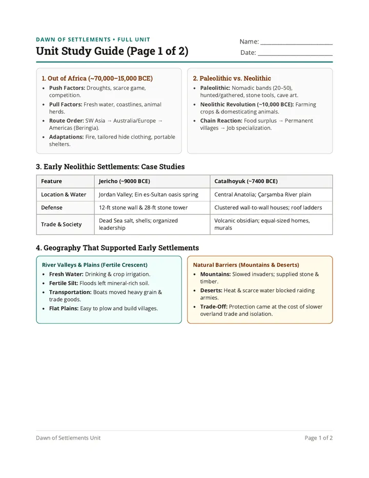
Unit Study Guide (Page 1 of 2)
Name: __________________________
Date: ___________________________
1. Out of Africa (~70,000–15,000 BCE)
Push Factors: Droughts, scarce game, competition.Pull Factors: Fresh water, coastlines, animal herds.Route Order: SW Asia → Australia/Europe → Americas (Beringia).Adaptations: Fire, tailored hide clothing, portable shelters.
2. Paleolithic vs. Neolithic
Paleolithic: Nomadic bands (20–50), hunted/gathered, stone tools, cave art.Neolithic Revolution (~10,000 BCE): Farming crops & domesticating animals.Chain Reaction: Food surplus → Permanent villages → Job specialization.
3. Early Neolithic Settlements: Case Studies
Feature
Jericho (~9000 BCE)
Catalhoyuk (~7400 BCE)
Location & Water
Jordan Valley; Ein es-Sultan oasis spring
Central Anatolia; Çarşamba River plain
Defense
12-ft stone wall & 28-ft stone tower
Clustered wall-to-wall houses; roof ladders
Trade & Society
Dead Sea salt, shells; organized leadership
Volcanic obsidian; equal-sized homes, murals
4. Geography That Supported Early Settlements
River Valleys & Plains (Fertile Crescent)
Fresh Water: Drinking & crop irrigation.Fertile Silt: Floods left mineral-rich soil.Transportation: Boats moved heavy grain & trade goods.Flat Plains: Easy to plow and build villages.
Natural Barriers (Mountains & Deserts)
Mountains: Slowed invaders; supplied stone & timber.Deserts: Heat & scarce water blocked raiding armies.Trade-Off: Protection came at the cost of slower overland trade and isolation.
Dawn of Settlements Unit Page 1 of 2
Dawn of Settlements • Full Unit
Unit Study Guide: Practice Check (Page 2 of 2)
Review Exercises
A. Define in Your Own Words
1. Domestication:
2. Fertile Silt:
3. Natural Barrier:
B. Case Study Review
4. How did Jericho and Catalhoyuk each protect their communities?
5. List three ways a river helped an early farming settlement succeed.
C. Geography Trade-Off
6. Why might a settlement near tall mountains or a desert be safer—but also have a harder time trading?
Dawn of Settlements Unit Page 2 of 2
Settlements Unit Assessment Dawn of Settlements • Final Assessment
Unit Assessment (Page 1 of 2)
Name: __________________________
Date: ___________________________
Part 1: Multiple Choice (2 pts each = 12 pts)
1. Which continent did Homo sapiens migrate from around 70,000 BCE?
A. Europe
B. Africa
C. Asia
D. Australia
2. Which trait describes Paleolithic life rather than Neolithic life?
A. Living in permanent mudbrick villages
B. Moving in small bands to hunt and gather
C. Storing surplus wheat in granaries
D. Raising herds of domesticated sheep
3. How did people enter their mudbrick homes in Catalhoyuk?
A. Through wide paved street doors
B. By climbing wooden ladders through the roof
C. Through underground stone tunnels
D. By boat canals inside the town
4. What volcanic glass was a major trade good in Catalhoyuk and found as far away as Jericho?
A. Bronze
B. Obsidian
C. Marble
D. Iron
5. Why did many early farming settlements develop in the Fertile Crescent and river valleys?
A. Rivers gave water, fertile silt, and transport
B. Steep cliffs made farming impossible
C. Deserts covered every acre of the valleys
D. Glaciers provided year-round ice roads
6. How did deserts and mountain ranges help early settlements?
A. They flooded fields with rich river silt
B. They acted as natural barriers against invaders
C. They made boat transportation faster
D. They guaranteed mild, rainy summers
Part 2: Geography & Terms Match (1 pt each = 4 pts)
7. Fertile Silt
8. Oasis Spring
9. Beringia
10. Food Surplus
A. Ice Age land bridge connecting Asia to North America.
B. Mineral-rich mud left behind by river floods.
C. Extra stored grain that allowed job specialization.
D. Fresh water source that supported Jericho in a dry valley.
Dawn of Settlements Unit Page 1 of 2
Dawn of Settlements • Final Assessment
Unit Assessment (Page 2 of 2)
Written Response • 14 Points
Part 3: Short Answer (4 pts each = 8 pts)
11. Compare Jericho and Catalhoyuk : Name one way they were similar and one way they were different .
12. Explain the Neolithic chain reaction : How did learning to farm lead to permanent villages and new jobs like pottery or weaving?
Part 4: Geography Synthesis (6 pts)
13. Imagine you are advising a Neolithic community on where to build a new town. Describe the ideal geographic location by explaining how at least three different geographic features (such as rivers, flat plains, mountains, or deserts) will support farming, transportation, and protection.
Dawn of Settlements Unit Page 2 of 2 • 30 Points Total
Unit Assessment Answer Key Teacher Guide & Answer Key • Final Assessment
Unit Finale Assessment (30 Minutes)
30 Points Total
30-Minute Testing Plan & Accommodations
0–3 min: Distribute assessment, read directions aloud, and clarify Part 4 requirements (3 geographic features).3–28 min: Independent assessment (25 min). Offer read-aloud or sentence frames for Part 3/4 as needed.28–30 min: Collect assessments. (Use the 2-page Unit Study Guide as homework or a prior 30-min review day.)
Answer Key (30 Points)
Part 1: Multiple Choice (2 pts each = 12 pts)
1. B (Africa) | 2. B (Moving in small bands) | 3. B (Rooftop ladders) | 4. B (Obsidian) | 5. A (Water, silt, transport) | 6. B (Natural barriers)
Part 2: Geography & Terms Match (1 pt each = 4 pts)
7. B (Fertile Silt) | 8. D (Oasis Spring) | 9. A (Beringia) | 10. C (Food Surplus)
Part 3: Short Answer (4 pts each = 8 pts)
11. Jericho vs. Catalhoyuk (2 pts similarity, 2 pts difference): Both were early Neolithic farming towns with mudbrick homes and long-distance trade. However, Jericho relied on an oasis spring and built a 12-ft stone wall/tower, while Catalhoyuk sat by a river and used wall-to-wall houses with rooftop ladders.
12. Neolithic Chain Reaction (4 pts): Farming produced a food surplus (extra stored food), so people stayed in permanent villages to guard fields and not everyone had to farm—allowing job specialization (potters, weavers, builders).
Part 4: Geography Synthesis Rubric (6 pts)
2 pts per geographic feature (up to 3 features = 6 pts): Student accurately explains how each feature supports the town—e.g., river for fresh water, fertile silt, and boat transportation; flat plains for plowing crops and building homes; mountains or desert for natural protection from raiders.
Dawn of Settlements Unit Unit Assessment Answer Key