North America Expedition Slides
Grade 4 Social Studies • Self-Guided Project
Google Classroom Mission
Political Maps & Country Inquiry Slideshow
North America Expedition
Map continental borders, decode political boundary terms, and create an independent Google Slides presentation on Canada or Mexico.
Student Directions
- Open your Expedition Research Log doc in Google Classroom. 2. Type your name on your cover sheet. 3. Follow the yellow directions box on each slide to build your final slideshow!
Explorer
Your Student Name
Pacing
Self-Guided 4 Steps
Final Project
Digital Slideshow
Mission Roadmap
Your Project Path at a Glance
4 Key Checkpoints
Student Directions
Review the 4 project checkpoints below. Complete Checkpoints 1 and 2 first before starting your country research in Checkpoint 3.
1
Map Detective
Locate Canada, Mexico, USA, and Caribbean island nations.
Map Checkpoint
2
Word Arsenal
Master terms: continent, country, state, province, county, and city.
Vocabulary Check
3
Country Inquiry
Select Canada or Mexico and gather evidence across 6 key topics.
Field Research
4
Digital Slideshow
Create your 5-7 slide presentation in Google Slides and submit!
Final Slide Deck
North America Expedition • Overview Self-Guided Progress Checklist
Checkpoint 1
Political Map of North America
Map Match Reference
Student Directions
Study the political map below. Match the colors to Canada, the USA, Mexico, the Caribbean, and the 3 surrounding oceans!
❄️ ARCTIC OCEAN PACIFIC OCEAN ATLANTIC OCEAN ALASKA (USA) CANADA ★ Ottawa UNITED STATES ★ Washington MEXICO ★ CDMX CARIBBEAN N E S W
Map Match Key
Red: Canada 10 provinces & 3 territories
Blue: United States 50 states + Alaska & Hawaii
Green: Mexico 31 states & Mexico City
Gold: Caribbean Island nations in Caribbean Sea
Use this map to verify worksheet #1!
North America Expedition • Step 1 of 4 Standard 2: Political Maps
Checkpoint 2
Geographic Power Words: Big to Small
Nested Boundaries
Student Directions
In your Google Classroom doc, match each term below with its definition, then write your personal nested address (City to Continent).
1. Continent
A massive landmass containing many separate nations.
Ex: North America
2. Country / Nation
An independent territory with its own self-ruling government.
Ex: Mexico, Canada, USA
3. State / Province
A regional division inside a nation that passes local laws.
Ex: Quebec, Texas, Sonora
4. County
A district inside a state managing local courts and services.
Ex: Orange County, Cook County
5. City
A populated center with local mayor and city council.
Ex: Toronto, Guadalajara, Denver
Nested Address Task
Fill in: City → County → State → Country → Continent!
North America Expedition • Step 2 of 4 Standard 2: Geographic Hierarchy
Checkpoint 3 • Choose Your Mission
Select Your Country: Canada or Mexico?
Choose 1 Focus Nation
Student Directions
Compare Canada and Mexico below. Choose ONE country to investigate and type your selection in the Google Classroom question prompt!
Mission A 🍁 ❄️ 🌲
Investigate Canada
The second-largest country on Earth by land area, with 10 provinces and 3 northern territories.
Indigenous Peoples (First Nations, Inuit, Métis)
Two Official Languages: English & French
Rocky Mountains, boreal forest & Ottawa capital
Focus: Northern biomes, arctic climates, and dual languages!
Mission B 🦅 ☀️ 🏛️
Investigate Mexico
A land of ancient civilizations, vibrant traditions, and 31 diverse regional states.
Maya, Aztec, and 68+ Indigenous cultures
Spanish language and rich regional arts
Rainforests, deserts, volcanoes & Mexico City
Focus: Ancient history, biodiversity, and vibrant cultures!
North America Expedition • Step 3 of 4 Standard 3: Country Selection
Field Research Guide
6 Required Topics to Investigate
Inquiry Log Categories
Student Directions
In your Google Classroom research log, write at least 2 verified facts for each of the 6 topics below for your chosen country.
1. Peoples & Languages
Indigenous heritage, ethnic groups, and official languages spoken.
2. Population & Cities
Total population count, capital city, and top 2 largest urban centers.
3. Form of Government
System of leadership (President / Prime Minister) and national laws.
4. Environment & Climate
Landforms (mountains, coastlines, plains) and regional climate zones.
5. Resources & Industry
Major agricultural crops, minerals, energy, and key manufacturing.
6. National Landmarks
At least 2 famous historic monuments or natural landmarks to spotlight.
North America Expedition • Step 3 of 4 Standard 3: 6 Inquiry Topics
Detective Toolkit
Consulting Multiple Types of Sources
Use At Least 3 Sources
Student Directions
Explore at least 3 source types below. For every source you use, record the title and website in your Works Cited section!
Satellite Images
Use Google Earth to view elevation, coastlines, and mountain ranges.
Visual Landscape
Atlases & Docs
Consult Britannica or World Book for verified population and capitals.
Verified Facts
Photographs
Find photos of traditional architecture, food, wildlife, and landmarks.
Cultural Evidence
News Articles
Read kid news (TIME for Kids) about conservation and daily life.
Current Events
North America Expedition • Source Evaluation Standard 3: Consulting Media
Final Checkpoint
Create Your Digital Slideshow & Submit
Turn-In Ready
Student Directions
Build your Google Slides presentation using the slide outline on the left. Complete your review checklist, attach your file, and click "Turn In"!
Slideshow Structure (5-7 Slides)
Google Slides
Slides 1-2: Title, Explorer Name, Political Map & Oceans
Slide 3: Peoples, Languages, Capital City & Government
Slide 4: Environment, Climate & Key Natural Resources
Slides 5-6: 2 Famous Landmarks & Works Cited (3 Sources)
Self-Check Before Turning In
Defined political terms (continent to city)
Covered all 6 topics for Canada or Mexico
Included satellite images, maps & photos
Cited at least 3 distinct research sources
Click "Turn In" on Google Classroom when attached!
North America Expedition • Final Step 4 of 4 Standard 3: Presentation Showcase
Field Research Graphic Organizer
North America Expedition • Grade 4
Field Research Graphic Organizer
Page 1 of 2
Student Name:
Date:
Country: Canada Mexico
1. Continental & Geographic Basics
Standard 2 & 3
Capital City & Population Size:
Capital:
Population:
Bordering Oceans & Neighboring Nations:
Oceans:
Borders:
Top 2 Major Cities (Other than Capital):
2. Peoples, Cultures & Languages
Standard 3
Official Language(s) Spoken: What languages are taught and used in government?
Indigenous & Ethnic Groups: First Nations, Inuit, Maya, Aztec, or regional heritages:
Cultural Tradition, Art, or Celebration:
3. Form of Government & Leadership
Standard 3
Type of Government:
National Leader Title:
How Laws Are Created:
Turn over to Page 2 to record Environment, Economy, Landmarks, and Sources. North America Field Research Log
Environment, Economy & Source Citations
Research Log • Part 2
Page 2 of 2
4. Environment, Landforms & Climate Zones
Standard 3
Major Landforms & Bodies of Water: Mountains, rivers, lakes, deserts, forests:
Climate Zones & Weather Patterns: Seasonal temperatures, rainfall, arctic/tropical:
5. Natural Resources & Key Industries
Standard 3
Key Natural Resources: Minerals, oil, timber, fresh water, agriculture:
Major Industries & Exports: Manufacturing, technology, tourism, trade:
6. National Landmarks Spotlight (Pick 2)
Historic or Natural
Landmark 1 Name & Location:
Why is it significant or historic?
Landmark 2 Name & Location:
Why is it significant or historic?
7. Works Cited: Source Detective Log (Record 3 Sources)
Maps • Encyclopedias • Photos • News
Source Title / Author
Type (Map, Book, News)
Website URL or Publisher
Source Title / Author
Type (Map, Book, News)
Website URL or Publisher
Source Title / Author
Type (Map, Book, News)
Website URL or Publisher
I verified all facts using at least 3 distinct sources before building my Google Slides deck. Ready for Google Slides Showcase
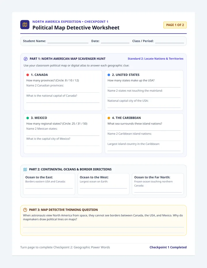
Map Detective Worksheet
North America Expedition • Checkpoint 1
Political Map Detective Worksheet
Page 1 of 2
Student Name:
Date:
Class / Period:
Part 1: North American Map Scavenger Hunt
Standard 2: Locate Nations & Territories
Use your classroom political map or digital atlas to answer each geographic clue:
1. Canada
How many provinces? (Circle: 8 / 10 / 12)
Name 2 Canadian provinces:
What is the national capital of Canada?
2. United States
How many states make up the USA?
Name 2 states not touching the mainland:
National capital city of the USA:
3. Mexico
How many regional states? (Circle: 25 / 31 / 50)
Name 2 Mexican states:
What is the capital city of Mexico?
4. The Caribbean
What sea surrounds these island nations?
Name 2 Caribbean island nations:
Largest island country in the Caribbean:
Part 2: Continental Oceans & Border Directions
Ocean to the East: Borders eastern USA and Canada:
Ocean to the West: Largest ocean on Earth:
Ocean to the Far North: Frozen ocean touching northern Canada:
Part 3: Map Detective Thinking Question
When astronauts view North America from space, they cannot see borders between Canada, the USA, and Mexico. Why do mapmakers draw political lines on maps?
Turn page to complete Checkpoint 2: Geographic Power Words Checkpoint 1 Completed
Geographic Power Words & Boundary Ladder
North America Expedition • Checkpoint 2
Page 2 of 2
Part A: Match the Political Boundary Terms
Write the letter in each blank
1. Continent
2. Country / Nation
3. State / Province
4. County
5. City
A. A populated urban center governed by a mayor and city council.
B. A large regional division within a country that makes local laws.
C. A massive continuous landmass containing many separate nations.
D. A smaller district inside a state that oversees courts and sheriffs.
E. An independent territory with its own self-ruling government.
Part B: My Personal Nested Geographic Address
Geography fits like stacking Russian nesting dolls (from small to large). Write your personal location:
Smallest 1. My City
District 2. My County