A comprehensive physical geography lesson compiling the 10 major world landforms. It features a premium, student-ready reading ledger, an interactive presentation, and a matching student settlement activity with detailed teacher guides.
1. Every landform has a geographic hazard (e.g., flooding, isolation, or drought). Identify the specific threat your selected site faces, and describe an architectural or cultural adaptation your settlers must build to survive it.
2. How will your colony trade with neighbors located on the other two landforms? Describe the physical transport methods (e.g., river barges, mountain paths) and what resources you will offer in exchange.
GLOBAL GEOGRAPHY SEQUENCE: EARTH SHAPES US PAGE 2 OF 2
Slide 3: River Valleys
Teacher Prompt: "Ancient Mesopotamia and Egypt grew rapidly. What was the exact cost of their hyper-rich soil?"
Key idea: Devastating seasonal floods that required centralized engineering (dams, levees) to control.
Slide 4: Great Plateaus
Teacher Prompt: "How does a plateau differ from mountains if you are building railways?"
Key idea: Once you scale the steep cliff sides, the flat plateau top offers highly predictable building paths.
Slide 5: The Plains
Teacher Prompt: "If plains allow the easiest infrastructure, why are they highly volatile?"
Key idea: Lack of geographical blockades makes territory highly vulnerable to sweeping invasions.
Student Worksheet Answer Key & Rubric
Part 1: Landform Matching Solutions
A. Mountains Connects to Option 2 (Extreme defense/Isolation)
C. Plateaus Connects to Option 3 (Mines & Grazing/Arid)
B. River Valleys Connects to Option 4 (Silt & Trade/Floods)
D. Coastal Plains Connects to Option 1 (Arable crops/No defenses)
Chooses a site but defends with generic terms ("nice climate", "good").
No choice marked; or defense lacks geography reference.
Mitigation Strategy
Identifies correct hazard (floods, dry climate) and presents structural cure.
Vaguely mentions threat but proposes unrealistic adaptation.
No hazard listed or left blank.
Trade Plan
Explains trade logistics based on landscape (e.g., river barges, highland roads).
Lists goods but skips explaining the physical routes of travel.
No trade strategies discussed.
Debrief Facilitation Structure (Last 10 minutes) Ask the class: "Who chose Site II (Serpent Estuary)? Defend against a Site I (Mt. Solitude) leader who says they will wait you out in a siege." Push them to discuss wealth vs defense, the foundational dilemma of human settlement history.
EARTH SHAPES US FACILITATION BLUEPRINT PAGE 2 OF 2
The Landform Ledger
SECTION 2
06
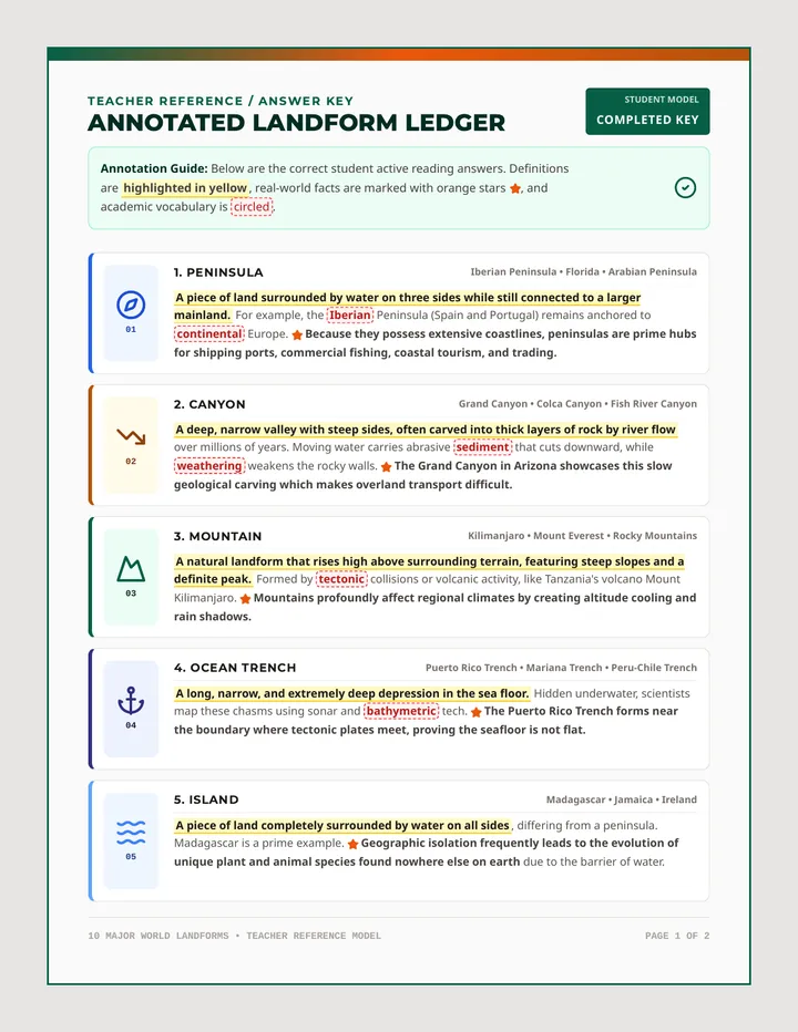
6. Delta
Nile Delta • Mississippi River Delta • Ganges-Brahmaputra
A flat, fan-shaped landform built from sediment deposits at a river's mouth. When a river hits the sea, its flow slows dramatically, dropping loads of rich sand, silt, and clay. The Nile Delta in Egypt creates a lush, green agricultural haven amid the desert. These fertile plains hold high water tables and support massive, highly dense farming civilizations.
07
7. Gulf / Bay
Gulf of Mexico • Bay of Bengal • Hudson Bay
A body of water partly enclosed by land but connected to a larger ocean or sea. The Gulf of Mexico borders the US and Mexico, offering sheltered waters. Unlike open coastlines, the protected geometry of gulfs and bays shelters ships from rough ocean storms, making them ideal places for trade ports, maritime industries, shipping, and coastal fisheries.
08
8. Mesa
Grand Mesa • Canyonlands • Mesa Verde
An elevated landform with a broad, flat top and steep cliffs. Resembling a table (the Spanish word for 'table' is *mesa*), they are common in dry environments like the American Southwest. A tough, erosion-resistant caprock shields the softer strata underneath. The flat tops of Grand Mesa in Colorado provide safe, elevated positions, but their steep cliffs impede ascent.
09
9. Rift Valley
East African Rift • Rio Grande Rift • Rhine Rift Valley
A long, low-lying region formed where tectonic plates split and pull apart. Deep fractures, volcanic vents, and tectonic basins develop along these faults. The East African Rift is a prime global display. While rifting occurs over millions of years, the active faulting generates freshwater lakes and fertile volcanic mineral zones that can sustain human life.
10
10. Sand Dune
Namib Desert Dunes • Great Sand Dunes • Sahara Dunes
A hill or shifting ridge of sand sculpted and migrated by wind power. When wind speed drops or strikes barriers, sand grains fall, accumulating over time. The massive dune fields of the Namib Desert are dynamic, constantly shifting position. Because sand dunes are mobile, they act as fragile, dry environments where laying roads or buildings is nearly impossible.
Critical Review Prompts
1. Contrast how a delta and a mesa impact agricultural possibilities.
2. Explain why gulfs & bays are critical to global ocean trade networks.
10 MAJOR WORLD LANDFORMS • COMPREHENSIVE TEXT PAGE 2 OF 2
07
7. Gulf / Bay
Gulf of Mexico • Bay of Bengal • Hudson Bay
A body of water partly enclosed by land but still connected to a larger ocean or sea. The Gulf of Mexico provides a perfect example. Its protected curve shelters ships from rough ocean winds, making it highly ideal for deep-water trading ports and fisheries.
08
8. Mesa
Grand Mesa • Canyonlands • Mesa Verde
An elevated landform with a broad, flat top and steep cliffs. Named after the Spanish word for table. Mesas form in dry climates where a resistant caprock layer shields softer stone layers underneath from sweeping rainwater erosion.
09
9. Rift Valley
East African Rift • Rio Grande Rift • Rhine Rift Valley
A long, low-lying region formed where tectonic plates split and pull apart. The East African Rift is a prime example. Tectonic activity along active faults creates major freshwater rift lakes and volcanoes that supply critical regional resources.
10
10. Sand Dune
Namib Desert Dunes • Great Sand Dunes • Sahara Dunes
A hill or shifting ridge of sand sculpted and migrated by wind power. Sand is deposited as wind slows. The mobile nature of dunes makes laying permanent infrastructure like roads or stone houses virtually impossible because the ground shifts.
Critical Review Prompts — Solved Answer Key
1. Contrast how a delta and a mesa impact agricultural possibilities.
A delta features flat, nutrient-rich alluvial silt and a high water table, making it highly optimal for farming crops. In contrast, a mesa has elevated, dry, and rocky terrain that makes agriculture highly difficult, supporting mostly livestock grazing instead.
2. Explain why gulfs & bays are critical to global ocean trade networks.
Their curved, partly enclosed shape acts as a geographic shield, protecting moored cargo ships from destructive open-ocean winds and strong waves. This allows cities to build stable trade ports and long-lasting shipping docks.
10 MAJOR WORLD LANDFORMS • TEACHER REFERENCE MODEL PAGE 2 OF 2