Globe Trekker Slides
L 3 Social Studies
World Maps & Globes
Learn about Earth's big land, oceans, halves, and map tools.
Focus
Map & Globe Tools
Big Question
What makes places special?
Time
2 Class Days
Our Goals & Standards
NYS Framework 3.1 & 3.2
What We Learn
Goal 3.1: Earth has huge pieces of land and water. We use maps and globes to study them.
Goal 3.2: We can find places around the world using maps, globes, and special lines.
Skill: Reading maps and finding clues
I Can...
- Tell how a map and a globe are different.
- Name and find Earth's 7 continents (big lands) and 5 oceans.
- Use the Equator, Prime Meridian, and Hemispheres (halves) to find places.
- Plan trips using compass directions (N, S, E, W).
Let's be world explorers!
Slide 2 of 10
Earth Tools: Maps & Globes
Two Models
The Globe
Round 3D Ball (Sphere)
- • Shows the true shape and size of land and water.
- • Shows how Earth tilts and spins.
- • You can only see one side of Earth at a time.
Best for: Seeing Earth's real shape and true sizes!
The Map
Flat 2D Picture
- • Shows the whole world flat at one time.
- • Easy to fold, carry, and look closely at places.
- • Causes stretching (distortion): places at the top and bottom look too big!
Best for: Taking on trips and finding paths!
5 Map Parts: 1. Title • 2. Compass Rose • 3. Map Key • 4. Scale • 5. Grid
The 7 Giant Lands: Continents
Earth's Land
A continent is a giant piece of land. Earth has 7 continents!
01. Asia
Biggest continent with the most people
02. Africa
Second biggest; home to the Nile River & Sahara
03. North America
Our home! Has the USA, Canada, and Mexico
04. South America
Home of the Amazon Rainforest & tall mountains
05. Antarctica
Icy land at the South Pole; no cities
06. Europe
Joined to Asia; has many countries
07. Australia / Oceania
Smallest continent; water is all around it (island land)
Memory Trick: North America & South America • Europe, Asia, Africa • Australia & Antarctica!
The 5 Big Oceans
Mostly Water!
Earth is called the "Blue Planet" because huge saltwater oceans cover most of Earth!
Pacific
The Biggest
Biggest and deepest ocean on Earth!
Touches Americas & Asia
Atlantic
The Busiest
Lies between the Americas and Europe/Africa.
East of North America
Indian
The Warmest
South of Asia, between Africa and Australia.
Warm water for ships
Southern
The Ring
Goes all the way around icy Antarctica.
Very cold & icy
Arctic
The Smallest
Shallow, icy ocean around the North Pole.
At the top of Earth
Think: Can a ship sail from the Atlantic to the Pacific? How? Slide 5 of 10
Day 1 Workshop: Build Your World Map
Hands-On Activity
1
Place Continents
Put the paper continents on big paper where you think they go.
Rule: Do NOT glue yet!
Check how far apart they are
2
Check & Fix
Look at the real World Map to check your sizes and spaces.
Make your map match!
Move pieces before gluing
3
Glue & Draw Equator
Glue pieces down. Draw and label the Equator (middle line).
Label continents & oceans!
Check your work
Talk With Your Group:
"What clues would help you make a better world map?"
The Four Hemispheres (Halves)
"Hemi" = Half of a Ball
The EQUATOR (0° Middle Line)
An imaginary side-to-side line around the middle of Earth.
Northern Hemisphere (Top Half)
North of the Equator (USA, Canada, Europe, Asia)
Southern Hemisphere (Bottom Half)
South of the Equator (Australia, Antarctica, parts of Africa & South America)
PRIME MERIDIAN (0° Up-Down Line)
An imaginary up-and-down line from North Pole to South Pole.
Western Hemisphere (Left Half)
West of the line: North & South America
Eastern Hemisphere (Right Half)
East of the line: Europe, Africa, Asia, Australia
Where do we live? The United States is in the Northern and Western Hemispheres!
Finding Your Way: Compass Directions
Compass Rose
Cardinal Directions
4 Main Ways
N
North
S
South
E
East
W
West
Memory Trick: "Never Eat Soggy Waffles" (Go around: N → E → S → W)
Ordinal Directions
In-Between Ways
NE
Northeast
Between N & E
SE
Southeast
Between S & E
NW
Northwest
Between N & W
SW
Southwest
Between S & W
Easy Rule: North and South always go first!
Remember: North on a map points to the North Pole, not always the front of our room!
Trip Lab: Planning Travel Paths
Day 2 Practice
Teacher Example
United States → Brazil
Way to Go: Go South / Southeast
Crosses: The Equator
Half Change: Northern → Southern
Water: Atlantic Ocean
Group Try 1
Kenya → China
Way to Go: Go Northeast (NE)
Ocean: Over the Indian Ocean
Continents: Africa to Asia
Trace this path with your finger!
Group Try 2
China → North America
Way to Go: Go East (E)
Ocean: Over the Pacific Ocean
Half Change: Eastern → Western
A round Earth connects around the back!
Who wants to show their group's path on the big map? Use your new map words!
Exit Ticket: World Trip Challenge
Your Turn
Your Final Explorer Job
Look at your labeled World Map. Pick two continents and write two ways to travel from one to the other!
Put These in Your Trip:
- • Start continent & end continent
- • Which direction (N, S, E, W, NE, SE, NW, SW)
- • At least one ocean you cross
- • Did you cross the Equator?
Example Answer:
"To go from North America to Africa, I sail southeast over the Atlantic Ocean and cross the Equator."
Turn in your Group World Map and your Exit Ticket!
Great job, World Explorers!
Global Navigator Exit Ticket
Social Studies • L 3
Global Navigator Exit Ticket
Circle the best answer for each question. Show what you know about maps!
Name:
Date:
Class:
1
Which Earth tool is a round 3D ball (sphere) that shows the real shape and size of Earth's land and water?
A A flat road map
B A globe
C A compass rose
D A map key
2
Which continent (giant piece of land) has water all around it and is the smallest of the seven continents?
A South America
B Africa
C Australia / Oceania
D Europe
3
The Equator is an imaginary line around the middle of Earth. It splits Earth into which two hemispheres (halves)?
A Northern and Southern
B Eastern and Western
C Atlantic and Pacific
D Top and Side
4
A ship is sailing halfway between South and West on a compass rose. What ordinal (in-between) direction is it going?
A Northwest (NW)
B Southeast (SE)
C Southwest (SW)
D Northeast (NE)
5
An explorer goes from the United States (North America) to Brazil (South America). Which way do they go, and what line do they cross?
A Go South and cross the Equator
B Go North and cross the Prime Meridian
C Go West over the Indian Ocean
D Go East over the Arctic Ocean
How do you feel about using maps and globes?
Still Learning Feeling Good I Got This!
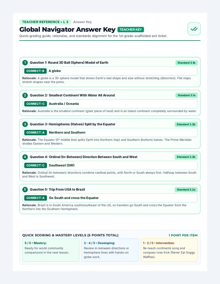
Global Navigator Answer Key
Teacher Reference • L 3 Answer Key
Global Navigator Answer Key TEACHER KEY
Quick-grading guide, rationales, and standards alignment for the 1st-grade-scaffolded exit ticket.
1 Question 1: Round 3D Ball (Sphere) Model of Earth
Standard 3.1b
CORRECT: B A globe
Rationale: A globe is a 3D sphere model that shows Earth's real shape and size without stretching (distortion). Flat maps stretch shapes near the poles.
2 Question 2: Smallest Continent With Water All Around
Standard 3.1a
CORRECT: C Australia / Oceania
Rationale: Australia is the smallest continent (giant piece of land) and is an island continent completely surrounded by water.
3 Question 3: Hemispheres (Halves) Split by the Equator
Standard 3.2b
CORRECT: A Northern and Southern
Rationale: The Equator (0° middle line) splits Earth into Northern (top) and Southern (bottom) halves. The Prime Meridian divides Eastern and Western.
4 Question 4: Ordinal (In-Between) Direction Between South and West
Standard 3.2b
CORRECT: C Southwest (SW)
Rationale: Ordinal (in-between) directions combine cardinal points, with North or South always first. Halfway between South and West is Southwest.
5 Question 5: Trip From USA to Brazil
Standard 3.2a
CORRECT: A Go South and cross the Equator
Rationale: Brazil is in South America south/southeast of the US, so travelers go South and cross the Equator from the Northern into the Southern Hemisphere.
Quick Scoring & Mastery Levels (5 Points Total) 1 Point per Item
5 / 5 • Mastery:
Ready for world community comparisons in the next lesson.
3 - 4 / 5 • Developing:
Review in-between directions or hemisphere lines with hands-on globe work.
1 - 2 / 5 • Intervention:
Re-teach continents song and compass rose trick (Never Eat Soggy Waffles).