Globe Trotters Slides GEOGRAPHY 101
Globe Trotters:
Continents & Oceans
A rookie explorer's guide to navigating our giant blue home. Learn to identify the 7 grand landmasses and 5 mighty oceans!
Atlas Adventurers Series
Set Sail
Our Blue Planet
Introduction
Two Worlds in One
If you looked at Earth from space, you'd see mostly blue . That's because over 70% of Earth is covered by saltwater!
The Continents
The 7 massive pieces of land that we live on, divided by natural lines and vast oceans.
The Oceans
The 5 vast bodies of connected saltwater surrounding all seven landmasses.
Fun Fact!
"All five oceans are actually connected as one single 'Global Ocean'! We break them up into five names to map and explore them better."
70% Water • 30% Land
Unit 1: Earth Basics Slide 2 of 8
The Seven Continents
The Land
From Biggest to Smallest
Earth has 7 major continents. Asia is the largest in size and population, while Australia is the smallest continent of all!
Mnemonic Trick: E at A n A pple A s A N ice S nack!"
1
Asia
Largest & home to Mt. Everest
2
Africa
Second largest, has Sahara Desert
3
North America
Includes US, Canada, Mexico
4
South America
Home to the Amazon Rainforest
5
Antarctica
Icy, cold, no permanent cities
6/7
Europe & Australia
Rich history & island wonders
Unit 1: Earth Basics Slide 3 of 8
Spotlight: North, South & Africa
Part 1
North America
3rd Largest
Surrounded by the Pacific, Atlantic, and Arctic Oceans. Features the rocky mountains, plains, and major rivers.
Key Landmark Grand Canyon
South America
4th Largest
Connected to North America by a tiny strip of land. Home to the world's largest river by water volume.
Key Landmark Amazon Rainforest
Africa
2nd Largest
The equator cuts right through the middle, making it the hottest continent. Famous for diverse wildlife.
Key Landmark The Nile River & Sahara
Unit 1: Earth Basics Slide 4 of 8
Spotlight: Asia, Europe, Australia & Antarctica
Part 2
Asia
The largest of all! Over 4.5 billion people live here. Includes countries like China, India, and Japan.
Mt. Everest
Europe
Shares the same physical landmass as Asia (often called "Eurasia") but is classified as its own continent.
Colosseum & Alps
Australia
The smallest continent and the only one that is also a single country! Entirely in the Southern Hemisphere.
Great Barrier Reef
Antarctica
The coldest, windiest, and driest continent. It is covered by a massive ice sheet and has no permanent residents.
South Pole & Penguins
Unit 1: Earth Basics Slide 5 of 8
The Five Oceans
The Oceans
Vast Connected Waters
While there is only one Global Ocean, mapmakers break it down into 5 distinct regions:
Pacific The largest and deepest. Bigger than all Earth's land combined!
Atlantic Second largest. Separates North/South America from Europe/Africa.
Indian The warmest ocean. Nestled between Africa, Asia, and Australia.
Southern Surrounds cold Antarctica. Very windy and full of floating icebergs.
Arctic Smallest, shallowest, and coldest. Mostly covered in sea ice at the top.
Sailor's Guide
The Mariana Trench
Located in the western Pacific Ocean, this is the deepest spot on the entire planet. It plunges nearly 36,000 feet down!
"Deep enough to submerge Mount Everest with thousands of feet to spare!"
Unit 1: Earth Basics Slide 6 of 8
Map Tools for Explorers
Navigation
Understanding Coordinates
Geographers draw imaginary lines across the globe to help us map out and navigate the world accurately.
A
The Equator
The imaginary belt around the earth's middle. It splits the earth into Northern and Southern hemispheres.
B
The Prime Meridian
The vertical line separating the Eastern and Western hemispheres, running straight through Greenwich, England.
The Compass Rose
N S W E
"Never Eat Shredded Wheat!N orth, E ast, S outh, W est"
Unit 1: Earth Basics Slide 7 of 8
Explorer Checkpoint
Quick Review
Question of the Day
Which is the smallest continent, and which is the largest and deepest ocean?
Think about the facts we just discussed! Talk to your partner and see if you can remember both names correctly.
Choose Your Path!
A Australia & Pacific Ocean
B Europe & Atlantic Ocean
C Asia & Indian Ocean
Grab your Atlas Adventurers Worksheet to begin your mapping mission!
Unit 1: Earth Basics Slide 8 of 8
Atlas Adventurers Reading Passage Logbook Entry #01 Explorer Edition
Charting the Great Blue Marble
A Traveler's Guide to the Continents and Oceans of Our World
Welcome, brave explorer! Imagine looking down at Earth from space. You would see a magnificent marble swirling with clouds, massive sheets of deep green land, and a vast blanket of deep blue water. Water covers more than 70% of Earth's surface . To help us find our way, mapmakers divide our planet into seven enormous blocks of land called continents , surrounded by five massive bodies of saltwater called oceans .
The Seven Continents
1. Asia: The giant of the East! It is the largest continent in size and population. Over 4.5 billion people live here, surrounded by monuments like the Great Wall and the snowy peaks of Mt. Everest.
2. Africa: The ultimate wilderness. Cut in half by the equator, Africa hosts the vast Sahara Desert and the mighty Nile River. It is famous for savannahs teeming with wildlife.
3. North America: Home sweet home! This land is surrounded by three oceans and is known for its soaring Rocky Mountains, grand canyons, and nations like Canada, Mexico, and the USA.
4. South America: A tropical wonder. Tucked beneath North America, it is home to the Amazon Rainforest, which breathes out 20% of Earth's oxygen, and the Andes mountains.
5. Antarctica: A frozen desert. It is the coldest, windiest continent on Earth. No towns or cities exist here—only busy scientists and tuxedo-wearing penguins!
6. Europe: A bustling home. Though physically connected to Asia, Europe is recognized as its own continent. It is famous for its rich history, castles, and historic cities.
7. Australia: The island continent. The smallest continent on Earth, Australia is also its own country! It is famous for kangaroos, koalas, and the Great Barrier Reef.
The Five Mighty Oceans
Pacific Ocean: The largest & deepest. Covers 1/3 of Earth!Atlantic Ocean: Separates the Americas from Europe & Africa.Indian Ocean: Warmest ocean, nestled below Asia.Southern Ocean: The icy waters surrounding Antarctica.Arctic Ocean: Smallest, coldest ocean covering the North Pole.
THE EQUATOR Splits Earth into Northern & Southern halves.
PRIME MERIDIAN Splits Earth into Eastern & Western halves.
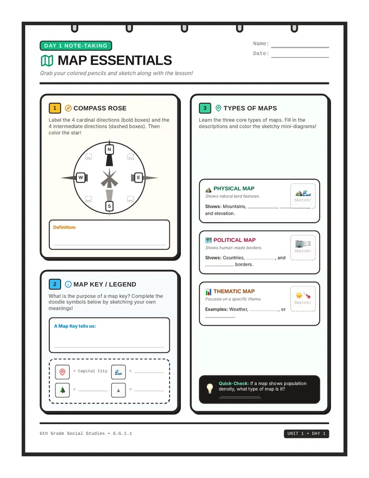
COMPASS ROSE Points cardinal directions: North, East, South, West.
Explorer Notes Worksheet Explorer Logbook Notes
Atlas Adventurers Student Companion Sheet
Name:
Date:
Your Mission: Fill in the logs below as you walk through the presentation or read the Explorer Logbook. Keep your eyes sharp and your mind active, voyager!
A The Big Blue Marble
1. Over
% of Earth's surface is covered by vast, saltwater oceans.
2. Earth has
massive pieces of land called continents, and
connected oceans.
3. While we name five different oceans, they are actually all joined as one giant
.
B Explorer Map Terms
Draw a line matching each geography term to its correct definition.
1. Equator
2. Prime Meridian
3. Compass Rose
Shows cardinal directions (N, S, E, W) to orient a map.
An imaginary belt around Earth's middle separating North and South hemispheres.
A vertical division line that splits the Western and Eastern hemispheres.
C Earth Facts Challenge
Continent Spotter
1. Which is the largest and most populated continent?
2. Which frozen continent is home only to scientists and penguins?
3. Which is the smallest continent and also its own country?
Ocean Navigator
1. What is the largest and deepest ocean on Earth?
2. Which is the coldest and smallest ocean at the North Pole?
3. Which ocean contains the deepest place on Earth (Mariana Trench)?
Atlas Adventurers • Guided Student Note-Taking Page 1 of 1
World Map Labeling Activity Riddle & Color Challenge
Atlas Adventurers Explorer Worksheet
Name:
Date:
Mission Briefing: Read the geographic riddles below to decode the secret identities of Earth's massive continents and oceans. Write the correct names in the spaces provided, then follow the Coloring Guide to color those exact regions on your printed world map sheet!
1. Explorer Riddles
Riddle 1 (Continent #3): I am the largest continent on Earth. I am home to the giant panda, high mountains, and Mount Everest!
My Identity:
Riddle 2 (Continent #7): I am located at the very bottom of the map. I am covered in thick ice and home only to scientists and emperor penguins!
My Identity:
Riddle 3 (Continent #6): I am both an island continent and my own country. Hop over here to see kangaroos and koalas!
My Identity:
Riddle 4 (Ocean C): I am the biggest and deepest ocean of all. I contain the mysterious and deep Mariana Trench!
My Identity:
Riddle 5 (Ocean A): I am the smallest and coldest ocean. I sit right at the top of the world at the icy North Pole!
My Identity:
Use the Word Bank from your reading or slides to help solve any tricky riddles!
2. Map Coloring Guide
Color the matching regions on your printed map using these guidelines:
Color Continent #1 (North America) Green
Color Continent #3 (Asia) Yellow
Color Continent #5 (Africa) Orange
Color Continent #6 (Australia) Brown
Color Ocean C (Pacific) & Ocean D (Indian) Light Blue
Color Ocean B (Atlantic) Dark Blue
Bonus Map Challenge: Find the Compass Rose on your printed map sheet and draw a bright yellow circle around it!
Atlas Adventurers • Riddle & Color by Number Activity Sheet Page 1 of 1
World Map Labeling Answer Key Educator Reference Only
Map Riddle Answer Key
Atlas Adventurers • Riddle & Color Solution Sheet
Teacher Copy
Grading Guidance: Use this quick-reference sheet to grade the Riddle & Color Map activity. Student riddle solutions are written out, and the geographic map identities are mapped below.
1. Riddle Solutions (Part 1)
Riddle 1 (3) Asia
Riddle 2 (7) Antarctica
Riddle 3 (6) Australia
Riddle 4 (C) Pacific Ocean
Riddle 5 (A) Arctic Ocean
Continents Reference (1-7)
<table class="w-full text-[11px] text-stone-700"><tbody><tr class="border-b border-stone-100"><td class="py-1 font-bold text-indigo-950 w-16">Continent 1:</td><td class="py-1 text-emerald-800 font-extrabold">North America</td></tr><tr class="border-b border-stone-100"><td class="py-1 font-bold text-indigo-950 w-16">Continent 2:</td><td class="py-1 text-emerald-800 font-extrabold">Europe</td></tr><tr class="border-b border-stone-100"><td class="py-1 font-bold text-indigo-950 w-16">Continent 3:</td><td class="py-1 text-emerald-800 font-extrabold">Asia</td></tr><tr class="border-b border-stone-100"><td class="py-1 font-bold text-indigo-950 w-16">Continent 4:</td><td class="py-1 text-emerald-800 font-extrabold">South America</td></tr><tr class="border-b border-stone-100"><td class="py-1 font-bold text-indigo-950 w-16">Continent 5:</td><td class="py-1 text-emerald-800 font-extrabold">Africa</td></tr><tr class="border-b border-stone-100"><td class="py-1 font-bold text-indigo-950 w-16">Continent 6:</td><td class="py-1 text-emerald-800 font-extrabold">Australia</td></tr><tr><td class="py-1 font-bold text-indigo-950 w-16">Continent 7:</td><td class="py-1 text-emerald-800 font-extrabold">Antarctica</td></tr></tbody></table>
Oceans Reference (A-E)
<table class="w-full text-[11px] text-stone-700"><tbody><tr class="border-b border-stone-100"><td class="py-1 font-bold text-indigo-950 w-16">Ocean A:</td><td class="py-1 text-emerald-800 font-extrabold">Arctic Ocean</td></tr><tr class="border-b border-stone-100"><td class="py-1 font-bold text-indigo-950 w-16">Ocean B:</td><td class="py-1 text-emerald-800 font-extrabold">Atlantic Ocean</td></tr><tr class="border-b border-stone-100"><td class="py-1 font-bold text-indigo-950 w-16">Ocean C:</td><td class="py-1 text-emerald-800 font-extrabold">Pacific Ocean</td></tr><tr class="border-b border-stone-100"><td class="py-1 font-bold text-indigo-950 w-16">Ocean D:</td><td class="py-1 text-emerald-800 font-extrabold">Indian Ocean</td></tr><tr><td class="py-1 font-bold text-indigo-950 w-16">Ocean E:</td><td class="py-1 text-emerald-800 font-extrabold">Southern Ocean</td></tr></tbody></table>
Bonus Check Ensure the Compass Rose has a yellow circle drawn around it.
Explorer Notes Answer Key Educator Reference Only
Explorer Notes Answer Key
Atlas Adventurers • Student Notes Solution Sheet
Teacher Copy
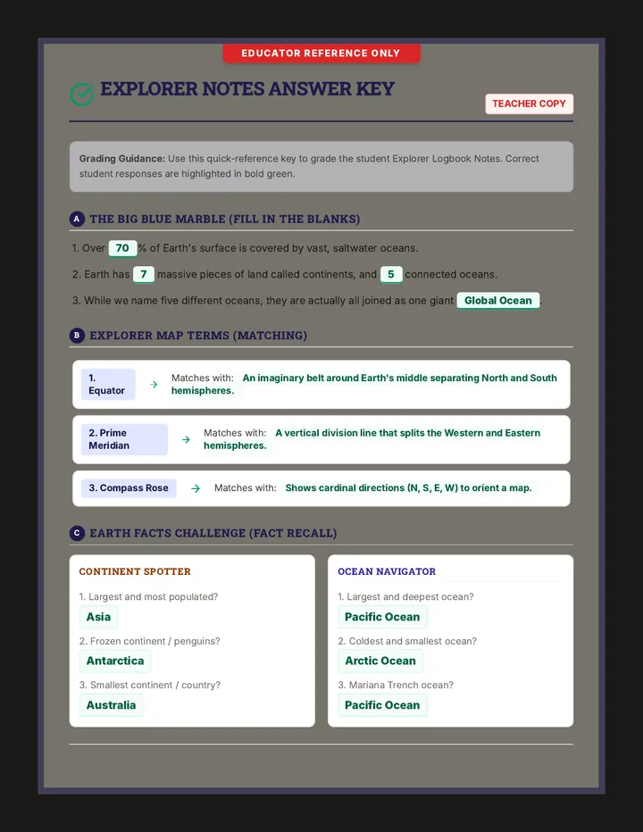
Grading Guidance: Use this quick-reference key to grade the student Explorer Logbook Notes. Correct student responses are highlighted in bold green.
A The Big Blue Marble (Fill in the Blanks)
1. Over 70% of Earth's surface is covered by vast, saltwater oceans.
2. Earth has 7 massive pieces of land called continents, and 5 connected oceans.
3. While we name five different oceans, they are actually all joined as one giant Global Ocean.
B Explorer Map Terms (Matching)
1. Equator Matches with: An imaginary belt around Earth's middle separating North and South hemispheres.
2. Prime Meridian Matches with: A vertical division line that splits the Western and Eastern hemispheres.
3. Compass Rose Matches with: Shows cardinal directions (N, S, E, W) to orient a map.
C Earth Facts Challenge (Fact Recall)
Continent Spotter
1. Largest and most populated?
Asia
2. Frozen continent / penguins?
Antarctica
3. Smallest continent / country?
Australia
Ocean Navigator
1. Largest and deepest ocean?
Pacific Ocean
2. Coldest and smallest ocean?
Arctic Ocean
3. Mariana Trench ocean?
Pacific Ocean
Atlas Adventurers • Explorer Notes Answer Key Page 1 of 1