A 4-day introductory world history sequence exploring how geographic location, natural barriers, and famous trade routes shaped the rise, wealth, and power of global empires.
Jot down these country examples in your handbook! Slide 5 of 10
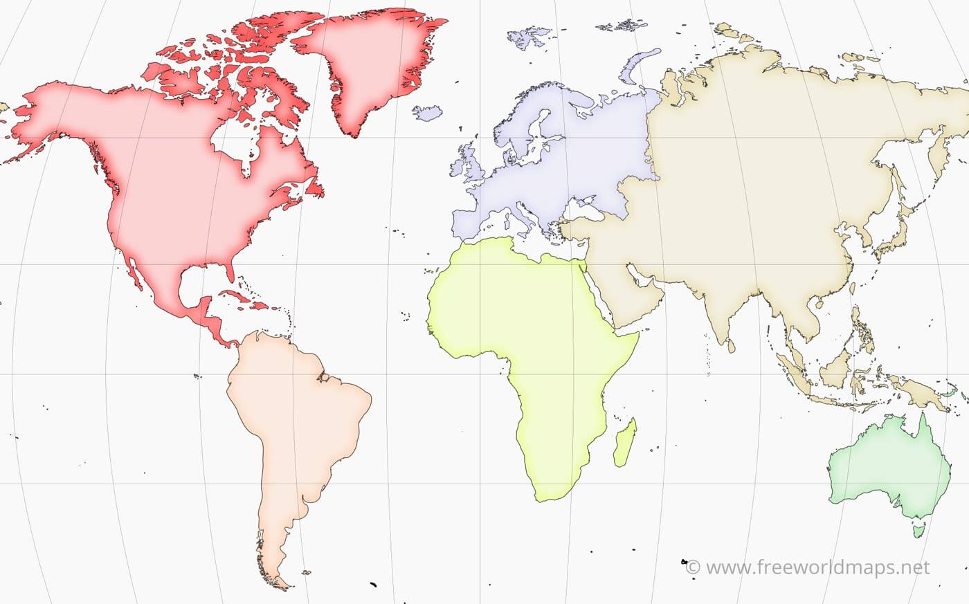
Spotlight: Europe & Africa
Passport Stop #3 & #4
🌎 Europe
6th Largest Continent
C
Densely populated with rich history, cool temperate weather. It has 44 countries and 740 million people.
Key Example Countries:
🇬🇧 United Kingdom • 🇫🇷 France • 🇩🇪 Germany
🌎 Africa
2nd Largest Continent
D
Features Sahara Desert and diverse climates. It has 54 countries and a soaring population of 1.4 billion people.
Key Example Countries:
🇳🇬 Nigeria • 🇪🇬 Egypt • 🇿🇦 South Africa
Write down countries for Europe (C) and Africa (D)! Slide 6 of 10
Spotlight: Asia & Australia/Oceania
Passport Stop #5 & #6
🌎 Asia
1st Largest Continent
E
Our biggest continent, spanning from deserts to the Himalayas. It has 49 countries and 4.7 billion people!
Key Example Countries:
🇨🇳 China • 🇮🇳 India • 🇯🇵 Japan
🌎 Australia / Oceania
Smallest Continent
F
An island continent with distinct wildlife (kangaroos!) and reefs. It has 14 countries and 43 million people.
Key Example Countries:
🇦🇺 Australia • 🇳🇿 New Zealand • 🇫🇯 Fiji
Write down countries for Asia (E) and Australia (F)! Slide 7 of 10
Spotlight: Antarctica
Passport Stop #7
🌎 Antarctica
5th Largest Continent
The coldest, windiest, and driest place on Earth. It is covered in a massive, thick layer of ice.
⚠️ Crucial Unique Facts:
❌ Has 0 countries and 0 permanent citizens.
🔬 Only scientists live here temporarily to study climate, glaciers, and penguins!
G
🐧 100% ICE
Label G in your handbook!
Antarctica has no cities or towns—just beautiful glaciers and ice sheets! Slide 8 of 10
The Five Grand Oceans
Earth's Water Systems
1
Pacific Ocean
The largest and deepest ocean. Separates the Americas from Asia.
2
Atlantic Ocean
The 2nd largest ocean. Sits between the Americas, Europe, and Africa.
3
Indian Ocean
Warmed body of water. Sits below Asia, bordering Africa and Australia.
4
Arctic Ocean
The smallest, shallowest ocean. Sits at the very freezing North Pole.
5
Southern Ocean
Surrounds the continent of Antarctica at the far South Pole.
💡 Tip: Notice how the numbers on this slide match the numbers on Page 3 of your workbook! Slide 9 of 10
It's Map Labeling Time!
Independent Activity
7-Minute Independent Practice
Turn to Page 3 of your handbook.
Use the Word Bank on the page.
Match the letters A - G to the correct continents.
Match the numbers 1 - 5 to the correct oceans.
Work on your own—we will review on the board together when the timer stops!
Do Your Best!
You are a brilliant explorer.
When we finish, we will complete the Exit Ticket to wrap up Day 1! Slide 10 of 10
Multisensory Engagement: During the slide tour, have students move their arms: reach up high for North, down low for South, right for East, and left for West!
Interactive Board Review: For the map labeling review, call students up to the smartboard to drag labels, write letters/numbers, or point to specific land masses.
Formative Exit Ticket Check: Collect Exit Tickets at the door. Quickly separate them into three piles (Mastery, Partial Mastery, Needs Support) to guide tomorrow's grouping.
Global Grid: Professional Teacher Guide Page 1 of 2
COMPLETE ANSWER KEYS
The Global Grid Reference Materials
MASTER KEYS
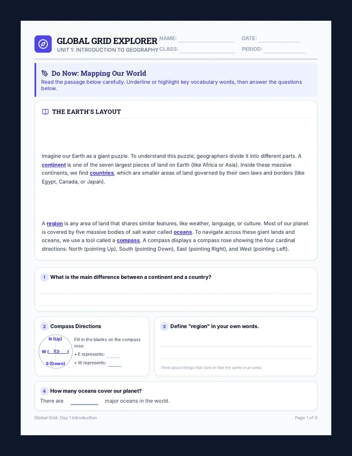
🔑 STUDENT HANDBOOK: PAGE 1 (DO NOW COMPREHENSION)
Q1 Difference between Continent & Country:
Continents are the seven largest pieces of land on Earth. Countries are smaller areas of land inside continents that have their own governments and borders.
Q2 Compass Rose Blank Labels:
E = East (Right)
W = West (Left)
Q4 Oceans Count:
There are 5 major oceans in the world.
Q3 Define "region" in own words:
(Answers will vary) A region is an area where things look similar. For example, a place where people speak the same language, eat similar food, or share the same hot weather.
1. Continent vs. Country: A continent is a huge block of land (7 on Earth); a country is a smaller, self-governing area inside a continent.
2. Region & Example: An area with shared characteristics. Examples: "The Middle East," "The Desert Region," "The Pacific Northwest."
PART 2: MAP READING & NAVIGATION
3. Africa East Travel: Students must write Indian Ocean.
4. Antarctica Fact: No countries/cities exist because it is covered in thick ice and has freezing, dry climates. Only scientists live there temporarily.
PART 3: COMPASS ROSE LABEL: Top: N • Bottom: S • Right: E • Left: W
Compass Role: Helps mapmakers draw borders, orient maps, and direct navigators.
Global Grid: Professional Teacher Guide Page 2 of 2
Slides 5-6: Case Studies
• Egypt: Settled on the Nile River. Flows North, but winds blow South. Boats can go either easily!
• Phoenicia: Settled on Mediterranean. Lacked good soil but used cedar trees to build massive trading .
DISCUSSION CHECK
Which country had to rely on sea trade because their farming land was poor?
Slide 7: Barriers
1. Mountains and deserts act as natural protecting kingdoms from being conquered.
2. However, these obstacles also completely block pathways.
STOP & JOT (Slide 7)
What is one positive thing and one negative thing about high mountain borders?
Power of Position: Lesson 2 Page 2 of 4
GEOGRAPHIC ADVANTAGES CHALLENGE
INDEPENDENT PRACTICE VISUAL MATCHING ACTIVITY
SLIDE 8 SUPPORT
Below are three stylized layouts of historic civilizations. Review their **geographic positioning**, read the descriptive cards, and write the matching letter (A, B, or C) in the answer boxes!
LAYOUT A RIVER EMPIRE
FLOW
🌾 Farms
🌾 Farms
🏠 Town
🏠 Town
Centered on a freshwater flow with crop farming on the muddy, flooded banks.
LAYOUT B PORT POWER
BAY
⚓ Port
Open Sea
Positioned in a deep-water harbor bay protecting merchant ships sailing oceanways.
LAYOUT C SHIELD VALLEY
⛰️ ⛰️
⛰️ ⛰️
Protected
Valleys
Enclosed on multiple sides by mountain peaks acting as physical shields against invasions.
Letter
EGYPT Position: The Nile River Valley
Relied heavily on massive annual floods to bring rich black mud (silt) to grow barley and wheat. Traders loaded wooden boats to float upstream to trade with central Africa.
Letter
PHOENICIA Position: Mediterranean Sea Shoreline
Lacked good farming soils but had massive cedar forests. Built vast deep-water ports inside rocky coves, allowing them to trade glass and precious purple paint across three continents.
Letter
GREECE & INDIA Position: Mountain Passes & Valleys
Utilized high, rocky ridges like the Himalayas or Aegean Ranges to isolate towns and protect them from foreign conquerors, keeping their language and unique cultures safe for centuries.
DISCUSSION TASK (Slide 9)
Discuss with a partner: If a country is locked inside high mountains with no rivers or seas, how would they trade for spices or gold? Write down your partner's top idea below:
Power of Position: Lesson 2 Page 3 of 4
EXIT TICKET: TRADING PLACES
DAY 2 FORMATIVE ASSESSMENT
Page 4 Assessment
Apply what you've learned about geographic advantages and trade to answer these short-answer questions.
1 Why were river valleys considered "natural highways" for early human merchants? Give one reason.
2 How was coastal ocean trade different from river trade? Think about directions and ship travel!
3 Mountains and deserts have a "double effect" on a kingdom. Describe how they can HELP a nation, and how they can HURT trade.
🛡️ How they HELP:
❌ How they HURT :
"Geography is not just about coordinates—it determines who wins, trades, and survives!"
Turn this entire packet in to the teacher at the end of class! Trading Places Assessment • Page 4 of 4
direction
🛡️ DESERT SHIELD: Flanked by massive, burning sand deserts that blocked enemy invasions.
NILE RIVER
🌾 wheat farms
🏠 Memphis
Look at Layout A in your handbook!
Because sailing both ways was easy, Egypt traded food crops for gold and luxury gems! Slide 5 of 9
Case Study: Phoenicians (Sea Merchants)
📝 Page 2 Guided Tracker
Phoenicia: Sea-Based Wealth
Fill in the **Phoenicia** bullet on Page 2 as we talk about their ships:
🌲 CEDAR FORESTS: Surrounded by huge forests of dense cedar trees, ideal for building ships.
⚓ COVES: Deep coastlines formed natural harbors, allowing them to trade glass and paint across continents with massive boats/ships.
DISCUSSION CHECK
"Which country had to rely on sea trade because their farming land was poor?"
Talk with your neighbor and write your answer in the blue check box on Page 2.
Phoenicians manufactured purple paint so rare that only kings could afford it! Slide 6 of 9
Physical Shields & Obstacles
📝 Handbook Page 2 • Slide 7
Fill in Section C on Page 2:
1
Mountains and deserts act as natural shields/barriers protecting kingdoms from being conquered.
2
However, these physical obstacles also completely block trade pathways.
STOP & JOT!
"What is one positive thing and one negative thing about high mountain borders?"
Write your thought in the amber box on Page 2.
High barriers make trading extremely slow, forcing countries to sail instead. Slide 7 of 9
Map Advantages Challenge
Independent Practice
7 Minutes Challenge (Page 3)
Turn to Page 3 of your Trading Places Handbook. Complete the following:
1. Analyze
Look at Layouts A, B, and C in the booklet diagrams.
2. Match
Write letters A, B, or C in the corresponding boxes.
3. Settle
Answer the prompt: River Valley or Sea Coast for your own country?
Work independently—we will check together on the board in 7 minutes! Slide 8 of 9
Partner Debate Challenge
📝 Handbook Page 3 Discussion Check
Let's Debate Trade & Position!
Look at the **Discussion Task** on the bottom of **Page 3** of your handbook:
"If a country is locked inside high mountains with no rivers or seas, how would they trade for spices or gold?"
Discussion Check steps:
Share your best crazy/creative trading idea with your neighbor.
Listen to your neighbor's idea.
Write your partner's top idea in the **Discussion Task box** at the bottom of Page 3.
Once you finish writing, prepare to work on your Trading Places Exit Ticket! Slide 9 of 9
Color Coding Matching: Project Page 3 of the Handbook on the screen. Color-code Layout A in yellow, Layout B in blue, and Layout C in orange to help students who struggle to track layout cards.
Trading Places: Professional Teacher Guide Page 1 of 2
COMPLETE ANSWER KEYS
Trading Places Reference Materials
MASTER KEYS
🔑 STUDENT HANDBOOK: PAGE 1 (DO NOW: WATERWAYS)
Q1 Why land trade was difficult:
Moving heavy goods over dry land, deserts, and forests was very slow, expensive, and dangerous because there were no trucks or paved roads.
Q2 Two advantages of rivers:
1. Fresh water and wet fertile soil (silt) for growing food crops.
2. Natural "water highways" to float heavy goods easily on rafts and boats.
Q3 How Phoenicians got rich:
They built deep-water ports on the Mediterranean coast and sailed massive wooden ships to trade luxury items like purple dyes and timber with other countries.
Q4 Landlocked definition:
A country that is completely surrounded by dry land, with no direct access to oceans or seas.
🔑 STUDENT HANDBOOK: PAGE 2 (GUIDED LECTURE NOTES)
Section A: Rivers
1. crops
2. soil / land
3. goods / cargo
Section B: Coasts
1. waves / storms
2. countries / lands
3. boats / ships
Section C: Barriers
1. shields / walls
2. attack / conquer
3. trade / shipping
🔑 STUDENT HANDBOOK: PAGE 3 (GEOGRAPHIC MATCHING)
EGYPT
LAYOUT A
PHOENICIA
LAYOUT B
GREECE / INDIA
LAYOUT C
🔑 EXIT TICKET ANSWER KEY: DAY 2
Q1: River Valleys as "Natural Highways"
Boats can carry heavy goods long distances smoothly with river currents, bypassing the strain of dragging items over mountain trails or dry deserts.
Q2: Coastal vs. River Trade
River trade moves back and forth along one single stream flow. Coastal trade uses ships to navigate the open sea in any direction, connecting to many foreign countries.
Q3: Mountains & Deserts Double Effect
• HELP: Act as tall walls (shields) preventing foreign armies from marching in.
• HURT: Block easy overland paths, making trading with neighbor civilizations incredibly slow.
Trading Places: Professional Teacher Guide Page 2 of 2
Timestamp 03:45 QUESTION 3
How can a country's climate (weather patterns) give it a "comparative advantage"?
A. Cold weather makes boats sail ten times faster. B. Having the perfect warm weather to easily grow cash crops like coffee or sugar. C. Having no winds so storms can never start. D. Deserts are the best place to find wheat and rice.
Video Stop-and-Jot Check
Based on the video, if a country has plenty of skilled glassmakers and rich sand resources, what should they specialize in producing and trading?
Power of Position: Lesson 3 Page 2 of 4
THE OPTIMAL ROUTE CHALLENGE
SPATIAL DECISION INDEPENDENT PRACTICE
7-MINUTE ACTIVITY
1 SET 1: THE DELICATE SILK CHALLENGE (Rome to China)
CARGO: FRAGILE SILK
• Route 1 (Sea Lanes): Long 4-month journey on calm, deep sea channels with protected port shelters. No bandits.
• Route 2 (Mountain Pass): Short 2-month shortcut across icy cliffs and rocky, bumpy trails with active bandit hideouts.
Choose One: 🌊 Route 1 ⛰️ Route 2
Rome China ⛰️ Bandits ⚓ Safe Bay
Justify: Why is this route the most optimal for carrying delicate silk?
2 SET 2: THE SCORCHING SAHARA CHALLENGE (Timbuktu to Egypt)
CARGO: HEAVY GOLD
• Route A (Short Sand Path): Fast 15-day walk straight through deep sand dunes. Lacks any natural water springs or oases.
• Route B (Oasis Caravan Route): Slower 30-day curved journey. Includes 3 water oasis stops to refill camel waters skins.
Choose One: 🏜️ Route A 🌴 Route B
Timbuktu Egypt 🔥 No Water 🌴 Oasis Stops
Justify: Why is this route the most optimal for ensuring your camel drivers survive?
DISCUSSION TASK (Slide 9)
Discuss with a partner: If a country is locked inside high mountains with no rivers or seas, how would they trade for spices or gold? Write down your partner's top idea below:
Power of Position: Lesson 3 Page 3 of 4
EXIT TICKET: HISTORIC HIGHWAYS
DAY 3 FORMATIVE ASSESSMENT
Page 4 Assessment
Apply your knowledge of trade routes and comparative advantage to answer these final short-answer questions.
1 In your own words, what is "comparative advantage"? How does a country's climate help create it?
2 Compare the geography of coastal **Venice** (deep harbor lanes) and mountainous **Switzerland** (locked in by peaks). Who had more initial success in global trade, and why?
3 Name one major trade route we discussed today, and identify what key goods were carried across it:
🗺️ Chosen Trade Route Name:
💰 Goods / Items Carried:
"Physical lines on a map become real wealth in history books."
Turn this entire packet in to the teacher at the end of class! Highways of History Assessment • Page 4 of 4
Route Challenge 1: Delicate Silk
📝 Page 3 Challenge 1
🌊 Route 1: Sea Lanes
Takes 4 Months (Long)
Sails across open coastal sea networks. It is a long journey, but waters are calm and merchant vessels can drop anchor in safe island ports regularly.
Danger profile:
🟢 LOW RISK • Safe harbors • Smooth sailing
⛰️ Route 2: Mountain Pass
Takes 2 Months (Short)
Cuts straight across steep rocky mountain ridges. High cliffs have narrow paths, severe blinding snowstorms, and deep caves where bandits lie waiting.
Danger profile:
🔴 HIGH RISK • Snow blocks • Bandit ambush threat!
📝 Answer Page 3 Set 1: Which route protects fragile silk from bumpy mountain trails? Slide 5 of 10
Route Challenge 2: Heavy Gold Caravan
📝 Page 3 Challenge 2
🏜️ Route A: Short Desert Trek
Takes 15 Days (Very Fast)
🔥
Cuts straight through deep sand dunes in a straight line. It is incredibly quick, but there are **zero oases** or freshwater wells along the entire way.
Survival risk:
🔴 EXTREME RISK • Dehydration • Camel death threat
🌴 Route B: Oasis Caravan Route
Takes 30 Days (Slower)
🌴
A winding path through the desert that circles slightly. It takes twice as long, but it directly connects **three natural water oases** to refill water skins.
Survival risk:
🟢 LOW RISK • Steady water • Safe resting camps
📝 Answer Page 3 Set 2: Which route is safest for ensuring your merchant crew survives? Slide 6 of 10
Positioning Showdown
Comparing Locations
⚓ Venice (Coastal Sea Portal)
100% WATER ACCESS
Venice is located directly on a deep, sheltered saltwater lagoon of the Adriatic Sea.
• Ships can load and unload goods easily.
• Directly connected to Asia, Africa, & Europe.
👑 Outcome: Became one of the richest empires ever.
🏔️ Switzerland (Inland Mountains)
0% WATER ACCESS
Switzerland is completely landlocked, enclosed by the colossal, icy peaks of the Swiss Alps.
• Ships could not reach them.
• Mountain paths were completely blocked by snow.
❌ Outcome: Slower initial trading growth compared to Venice.
💡 Hint: This slide will help you answer Question 2 on your Lesson 3 Exit Ticket! Slide 7 of 10
Partner Debate Challenge
📝 Page 3 bottom box
Let's Brainstorm!
Look at the **Discussion Task** on the bottom of **Page 3** of your handbook:
"If a country is locked inside high mountains with no rivers or seas, how would they trade for spices or gold?"
Write their best idea in the **Discussion Box** on Page 3!
Collaborating with friends makes geographic planning much easier! Slide 8 of 10
Worktime & Activity
Independent Focus
7-Minute Independent Activity
Turn to Page 3 of your handbook.
Analyze **Set 1** (Silk Road) and select the optimal route for fragile cargo. Explain why!
Analyze **Set 2** (Sahara caravan) and select the optimal route for water survival. Explain why!
Answer in clear, complete sentences!
Be a Geographic Expert!
We will review our route choices on the board together in 7 minutes! Slide 9 of 10
Day 3 Exit Ticket Time
Lesson 3 Assessment
Complete Page 4 of Your Booklet
Complete the **Exit Ticket on Page 4** of your packet independently to demonstrate your understanding of trade routes, comparative advantage, and country position comparative values.
Exit Ticket Checklist:
✔️ Explain "comparative advantage" in your own words.
✔️ Compare coastal Venice vs. mountain Switzerland.
✔️ Identify one historic trade route and what items moved across it.
🔔 Hand your booklet directly to the teacher as you leave! Slide 10 of 10
Roleplay the Merchant: Choose a student to act as a Roman merchant who must deliver silk. Ask the class to shout out warnings as they "cross" the dangerous mountain pass (red route) or float along the safe sea ports (green route).
Highways of History: Professional Teacher Guide Page 1 of 2
COMPLETE ANSWER KEYS
Highways of History Reference Materials
MASTER KEYS
🔑 STUDENT HANDBOOK: PAGE 1 (DO NOW: WORLD SHAPING ROUTES)
Q1 Regions connected by the Silk Road:
It connected China (or Asia) with Europe.
Q2 Why West Africans traded gold for salt:
West Africa had plenty of gold but lacked salt deposits. They desperately needed salt to preserve their meats and survive, making salt as valuable as gold to them.
Q3 How natural geography determines what goods are traded:
Geography controls the resources a country starts with (soil, minerals, weather). If a country has natural gold mines or coastal access, they will trade those items with nations that lack them.
Justify: Silk is extremely fragile and delicate. Shaking it on bumpy, rocky mountain wagon trails (Route 2) would rip or damage it, and snowy trails make it wet. Sea lanes are smooth and protected.
🐪 CHALLENGE SET 2 (Sahara):
• Optimal Route: Route B (Oasis Route)
Justify: Even though Route B takes longer (30 days vs 15), desert heat is lethal. Drivers and camels cannot survive 15 days of zero water. Oasis stops ensure they can drink and stay alive.
Comparative advantage is when a nation's geography makes it cheap and easy to make a specific product. Climate plays a role by providing the perfect heat, sun, or rain to grow specialized crops (like coffee or sugarcane) without expensive greenhouses.
Q2: Venice vs. Switzerland
Venice had much more initial success. Being directly on the sea allowed merchant fleets to load cargo easily and sail directly to foreign markets, while landlocked Switzerland was blocked by towering Swiss Alps and frozen, dangerous mountain gaps.
Q3: Selected Trade Route & Cargo
• Silk Road: Carried delicate Chinese silk, paper, and valuable spices in exchange for European gold and glassware.
• Trans-Saharan: Carried North African mineral salt to West Africa in exchange for precious gold coins and bars.
Highways of History: Professional Teacher Guide Page 2 of 2
Question 5
"I am a continent. I am covered in thick glaciers, have 0 countries, and only penguins and scientists live on me. What is my name?"
Slide 7 of 15
💧 round 6: ocean check
Map Showdown Game
Question 6
"If a wooden ship sails straight WEST from South America, which massive ocean are they crossing?"
Slide 8 of 15
💧 round 7: ocean check
Map Showdown Game
Question 7
"Which ocean surrounds the icy continent of Antarctica on the far South Pole?"
Slide 9 of 15
🧭 round 8: navigation check
Map Showdown Game
Question 8
"If you start in South America and sail a trade ship directly NORTH, which continent will you hit first?"
Slide 10 of 15
💧 round 9: ocean check
Map Showdown Game
Question 9
"Which ocean sits directly EAST of Africa and directly SOUTH of Asia? Raise my card!"
Slide 11 of 15
🔥 round 10: continent check
Map Showdown Game
Question 10
"I am a continent completely surrounded by water. I am home to unique animals like kangaroos, and I am the smallest continent. What is my name?"
Slide 12 of 15
🧭 round 11: direction check
Map Showdown Game
Question 11
"If you sail a merchant boat straight WEST from Africa, which ocean are you crossing to reach South America?"
Slide 13 of 15
🔥 round 12: continent check
Map Showdown Game
Question 12
"I am a continent. I sit directly NORTH of Africa. I am home to countries like France and Germany. What is my name?"
Slide 14 of 15
🏆 round 13: final geographic check
Map Showdown Game
Question 13
"What do geographers call a country that is completely surrounded by land, with NO direct water access to any ocean?"
Slide 15 of 15
A. Gold was worthless and they wanted to get rid of it. B. They had no gold but plenty of natural salt lakes. C. They needed salt to preserve their food and stay alive. D. Salt was used to build giant wooden ships.
13. (5 pts) Why did early human civilizations choose to settle directly next to river valleys?
A. Rivers provided freshwater and silt (rich farming soil). B. Rivers blocked bandits and made invasion impossible. C. Rivers are landlocked with zero transportation flow. D. Rivers are covered in ice layers all year round.
D PART 4: GEOGRAPHIC SYNTHESIS SHORT ANSWER (Questions 14-15) 10 POINTS TOTAL
14. (5 pts) Explain how a flowing river valley acted as a "natural highway" for trade in ancient times. Give one concrete benefit:
15. (5 pts) Mountains and deserts have a "double effect" on a nation. Describe how they can HELP a country's safety, and how they can HURT trade paths:
🛡️ How they HELP:
❌ How they HURT :
"Double check all your answers before handing your paper to the teacher!"
Geography Unit Quiz 1 Page 2 of 2
Map Pointing: Call on "Game Champions" during the slides to walk up and point to the projected map symbols on the screen.
Map Showdown: Professional Teacher Guide Page 1 of 2
COMPLETE ANSWER KEYS
Map Showdown & Unit Quiz Keys
MASTER KEYS
🔑 SHOWDOWN REVIEW SLIDESHOW KEYS
• Slide 3 (Q1): SOUTH of Europe = Africa
• Slide 4 (Q2): Frozen Ocean at North Pole = Arctic Ocean
• Slide 5 (Q3): EAST from Rome to trade silk = Asia
PART 1: MAP LABELING (Questions 1-5 • 5 pts each = 25 pts)
1. Asia: E
2. South America: B
3. Africa: D
4. North America: A
5. Atlantic Ocean: 2
PART 2: VOCABULARY MULTIPLE CHOICE (Questions 6-10 • 10 pts each = 50 pts)
Q6 (Continent): B
Q7 (Region): A
Q8 (Advantage): C
Q9 (Landlocked): A
Q10 (Ocean): C
PART 3: HISTORIC TRADE CHECKS (Questions 11-13 • 5 pts each = 15 pts)
Q11 (Silk Road): B (Silk/Spices)
Q12 (Gold-Salt): C (Preserve meat)
Q13 (Rivers): A (Freshwater/Silt)
PART 4: SHORT ANSWER SYNTHESIS (Questions 14-15 • 5 pts each = 10 pts)
Question 14 (Rivers as Highways):
Rivers were natural highways because moving heavy goods on water currents with boats is much easier, faster, and cheaper than dragging cart loads across steep mountain passes or muddy terrain.
Question 15 (Mountains Double Effect):
• HELP: Tall, rocky mountains act as tall defensive walls (shields) preventing foreign armies from marching in.
• HURT: They block land pathways, making trading commodities with other nations extremely slow and difficult.
Map Showdown: Professional Teacher Guide Page 2 of 2