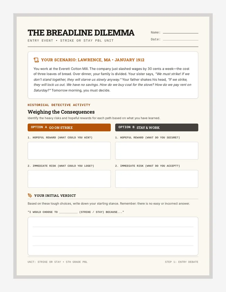
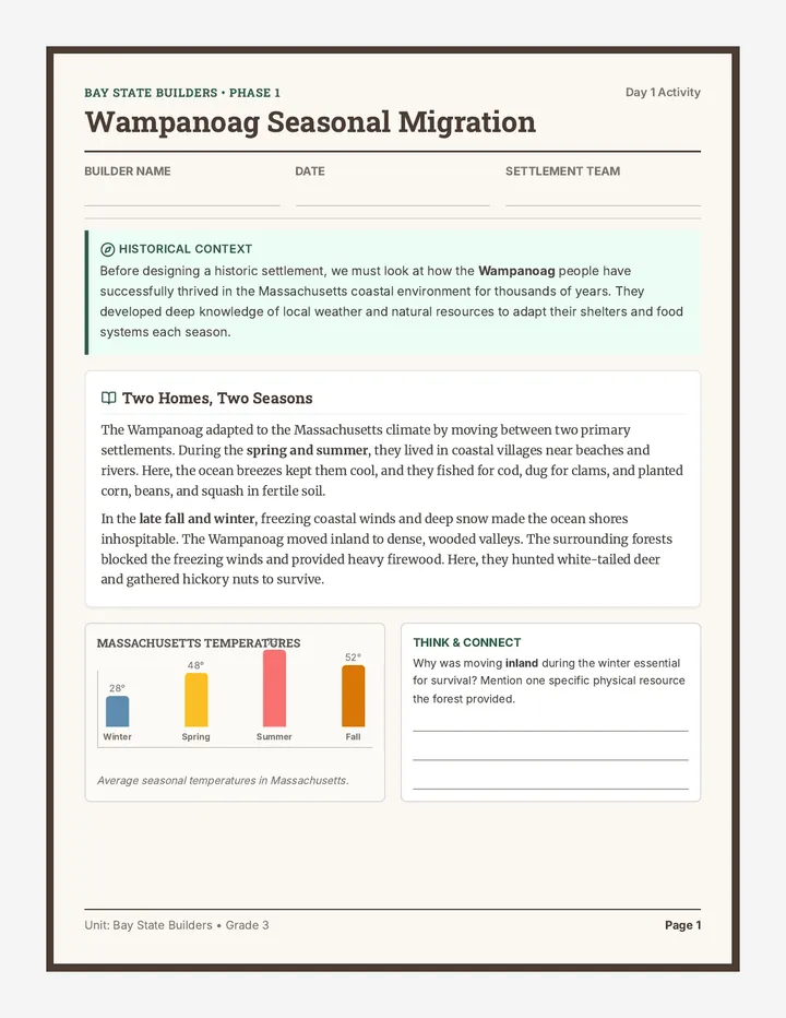
Border Lines Activity
A thumbs-up/thumbs-down activity worksheet based on a historical passage about Harriet Tubman and the Mason-Dixon Line, featuring 6 comprehension statements for students to evaluate and a reference placeholder for Image 3A-1.
Border Lines Answer Key
An answer key and teacher facilitation guide for the Border Lines Activity, providing correct answers and source references from the text.
Mason Dixon Visual Aid
A historical reference visual aid (Image 3A-1) showing the Mason-Dixon Line as a boundary between Pennsylvania and Maryland, illustrating the division between the North and South in 1850. The line marker has been moved to the right with an arrow.
Fields of Difference Activity
A thumbs-up/thumbs-down activity worksheet based on a historical passage about the differences between Northern and Southern economies, featuring 6 comprehension statements and a reference to Image 3A-2.
Fields of Difference Answer Key
An answer key and teacher guide for the Fields of Difference Activity, providing correct answers and context for the economic differences between the North and South.
Industrial North Activity
A thumbs-up/thumbs-down activity worksheet based on a historical passage about the Northern industrial economy, featuring 6 comprehension statements and a reference to Image 3A-3.
Industrial North Answer Key
An answer key and teacher guide for the Industrial North Activity, providing correct answers and context for the Northern industrial economy.
Factory Workers Activity
A thumbs-up/thumbs-down activity worksheet based on a historical passage about Northern factory workers and perspectives on slavery, featuring 6 comprehension statements and a reference to Image 3A-4.
Factory Workers Answer Key
An answer key and teacher guide for the Factory Workers Activity, providing correct answers and context for northern labor and perspectives on slavery.
Voices of Freedom Activity
A thumbs-up/thumbs-down activity worksheet based on a historical passage about the abolitionist movement and leaders like Frederick Douglass and Susan B. Anthony, featuring 6 comprehension statements and a reference to Image 3A-5.
Voices of Freedom Answer Key
An answer key and teacher guide for the Voices of Freedom Activity, providing correct answers and context for the abolitionist movement.
Tracks to Freedom Activity
A thumbs-up/thumbs-down activity worksheet based on a historical passage about Harriet Tubman as an abolitionist and conductor on the Underground Railroad, featuring 6 comprehension statements and a reference to Image 3A-6.
Tracks to Freedom Answer Key
An answer key and teacher guide for the Tracks to Freedom Activity, providing correct answers and context for Harriet Tubman's role in the Underground Railroad.
Abolitionist Press Activity
A thumbs-up/thumbs-down activity worksheet based on a historical passage about the power of abolitionist newspapers and their influence on leaders like Abraham Lincoln, featuring 6 comprehension statements and a reference to Image 3A-7.
Abolitionist Press Answer Key
An answer key and teacher guide for the Abolitionist Press Activity, providing correct answers and context for the role of abolitionist newspapers.
Rebel Spirit Activity
A thumbs-up/thumbs-down activity worksheet based on a historical passage about acts of rebellion against slavery, including Harpers Ferry and Nat Turner's rebellion.
Rebel Spirit Answer Key
An answer key and teacher guide for the Rebel Spirit Activity, providing correct answers and context for historical acts of rebellion against slavery.
Divided Growth Activity
A thumbs-up/thumbs-down activity worksheet based on a historical passage about U.S. expansion and the growing conflict over slavery in the 1850s, featuring 6 comprehension statements and a reference to Image 3A-9.
Divided Growth Answer Key
An answer key and teacher guide for the Divided Growth Activity, providing correct answers and context for U.S. expansion and the slavery conflict.
Watchful Guardian Activity
A thumbs-up/thumbs-down activity worksheet based on a historical passage about Harriet Tubman guarding runaways in the forest, featuring 6 comprehension statements and a reference to Image 2A-1.
Watchful Guardian Answer Key
An answer key and teacher guide for the Watchful Guardian Activity, providing correct answers and context for Harriet Tubman guarding runaways in the forest.
Strong and Rebellious Activity
A thumbs-up/thumbs-down activity worksheet based on a historical passage about Harriet Tubman growing strong and facing the danger of being sold to the Deep South, featuring 6 comprehension statements and a reference to Image 2A-2.
Strong and Rebellious Answer Key
An answer key and teacher guide for the Strong and Rebellious Activity, providing correct answers and context for Harriet Tubman's early life and decision to escape.
The Secret Railroad Activity
A thumbs-up/thumbs-down activity worksheet based on a historical passage about the Underground Railroad and Harriet Tubman's role as a conductor, featuring 6 comprehension statements and a reference to Image 2A-3.
The Secret Railroad Answer Key
An answer key and teacher guide for the Secret Railroad Activity, providing correct answers and context for the Underground Railroad and Harriet Tubman's returns to the South.
Swamp Escape Activity
A thumbs-up/thumbs-down activity worksheet based on a historical passage about Harriet Tubman leading people out of a swamp and using a secret knock at a safe house.
Swamp Escape Answer Key
An answer key and teacher guide for the Swamp Escape Activity, providing correct answers and context for Harriet Tubman's evasion tactics and the secret knock.
Safe Haven Activity
A thumbs-up/thumbs-down activity worksheet based on a historical passage about a woman helping fugitives hide in a chicken coop and providing food.
Safe Haven Answer Key
An answer key and teacher guide for the Safe Haven Activity, providing correct answers and context for the story of the woman helping fugitives.
The Drinking Gourd Activity
A thumbs-up/thumbs-down activity worksheet based on a historical passage about Harriet Tubman teaching a child how to find the North Star using the "drinking gourd" (Big Dipper).
The Drinking Gourd Answer Key
An answer key and teacher guide for the Drinking Gourd Activity, providing correct answers and context for the celestial navigation lesson.
Gathering Storm Activity
A thumbs-up/thumbs-down activity worksheet based on a historical passage about the town of Alton, Illinois in 1858, featuring 6 comprehension statements and a reference to Image 4A-1.
Gathering Storm Answer Key
An answer key and teacher guide for the Gathering Storm Activity, providing correct answers and context for the Alton, Illinois 1858 setting.
The Eager Crowd Activity
A thumbs-up/thumbs-down activity worksheet based on a historical passage about the meeting of two friends in a crowd gathered to hear Illinois politicians, featuring 6 comprehension statements.
The Eager Crowd Answer Key
An answer key and teacher guide for the Eager Crowd Activity, providing correct answers and context for the October 1858 gathering in Alton, Illinois.
The Great Debate Activity
A thumbs-up/thumbs-down activity worksheet based on a historical passage about the Lincoln-Douglas debates, featuring 6 comprehension statements about state sovereignty and Lincoln's views on slavery.
The Great Debate Answer Key
An answer key and teacher guide for the Great Debate Activity, providing correct answers and context for the discussion on states' rights and slavery.
A Choice to Make Activity
A thumbs-up/thumbs-down activity worksheet based on a historical passage where Frank expresses doubt and learns about the final Lincoln-Douglas debate in Alton.
Choice to Make Answer Key
An answer key and teacher guide for the Choice to Make Activity, providing correct answers and context for the discussion between Frank, Tom, and Mr. Foote.
Heart of the Debate Activity
A thumbs-up/thumbs-down activity worksheet based on a historical passage about U.S. expansion and the 1858 map, focusing on the debate over slavery's spread to new territories.
Heart of the Debate Answer Key
An answer key and teacher guide for the Heart of the Debate Activity, providing correct answers and context for the 1858 U.S. map and the debate over expansion.
The Two Candidates Activity
A thumbs-up/thumbs-down activity worksheet based on a historical passage about Abraham Lincoln and Stephen Douglas, their backgrounds, and their differing views on slavery.
The Two Candidates Answer Key
An answer key and teacher guide for the Two Candidates Activity, providing correct answers and context for the backgrounds of Lincoln and Douglas.
Harriet Tubman Escape Slides
A visual slide deck covering the key historical events of Harriet Tubman's escape and the sectional differences between the North and South, including Thumbs Up/Thumbs Down activity slides.
A House Divided Activity
A thumbs-up/thumbs-down activity worksheet based on Abraham Lincoln's "House Divided" argument and the outcome of the 1858 Senate race against Stephen Douglas.
A House Divided Answer Key
An answer key and teacher guide for the Divided House Activity, providing correct answers and context for Lincoln's 1858 debate and the "House Divided" argument.