Atmosphere Alert Reading Passage
Earth Science Investigation • Meteorology SECTION 04 : ATMOSPHERIC DYNAMICS
Atmosphere Alert: Air Pressure & Weather
How invisible forces of falling and rising air shape our everyday forecast
Name:
Date:
Period:
1 The Invisible Ocean Above Us
We live at the bottom of a vast ocean of gas known as the atmosphere. Although air feels weightless, Earth's gravity constantly pulls billions of gas molecules toward the surface. This downward force exerted on an area is called atmospheric pressure (or air pressure). Meteorologists measure this force using an instrument called a barometer, typically in units of millibars (mb) or inches of mercury (inHg). Air pressure is greatest at sea level because the entire weight of the atmosphere rests above it. As you hike up a mountain, pressure drops steadily because fewer air molecules remain overhead.
High-Pressure Systems (H) Anticyclone
In a high-pressure system, cool air is relatively dense and sinks downward toward the surface. As sinking air nears the ground, it warms and expands outward. This warming prevents water vapor from condensing, which means clouds struggle to form.
• Weather: Clear, sunny skies, dry air, light winds
• Rotation: Clockwise & outward (Northern Hemisphere)
Low-Pressure Systems (L) Cyclone
In a low-pressure system, warm air is less dense and rises upward into the troposphere. As it lifts, the air expands and cools to its dew point, causing water vapor to condense around dust particles to create thick clouds and precipitation.
• Weather: Overcast clouds, precipitation, gusty winds
• Rotation: Counterclockwise & inward (Northern Hemisphere)
The Meteorologist's Golden Rule
A rising barometer signals incoming fair, stable weather. A falling barometer warns of approaching storms and unsettled skies.
2 Wind: Nature's Pressure Balancer
Air is restless; it never stays still when an imbalance exists. Nature always seeks equilibrium, so air automatically rushes from areas of high pressure toward areas of lower pressure. This horizontal movement of air is what we experience as wind. The greater the difference in pressure between two neighboring regions, the steeper the pressure gradient becomes, and the faster the winds blow. On weather maps, meteorologists draw smooth concentric lines called isobars connecting locations of equal pressure. When isobars are spaced tightly together, expect vigorous, howling winds.
3 Colliding Air Masses and Fronts
When huge pools of air with different temperatures and moisture levels collide, they do not mix easily. The boundary separating them is called a front. At a cold front, a wedge of dense, colder air plows underneath a warm air mass, shoving the warm moisture rapidly upward and generating sudden, intense thunderstorms. At a warm front, advancing warm air gently rides over cold air, producing gradual sheet clouds and steady, long-lasting drizzle. Tracking pressure changes along these fronts allows meteorologists to forecast dramatic weather shifts hours before they strike.
Earth Science Student Handout • Reading Passage Page 1 of 2 Turn page for Comprehension Questions
Comprehension & Analysis 10 QUESTIONS • 100 POINTS
Air Pressure & Weather Assessment
Directions: Carefully read each question based on the passage. Fill in the bubble next to the single best response for each item.
- What causes atmospheric pressure at Earth's surface?
A Gravitational pull holding gas molecules down
B Heat energy radiating from the core
C Solar winds pushing into the upper exosphere
D Ocean evaporation generating upward momentum
- Why does air pressure decrease as altitude increases?
A Temperatures get warmer near mountain summits
B Fewer air molecules remain stacked overhead
C Wind speeds destroy gas molecules permanently
D Water vapor expands and displaces all nitrogen
- Which conditions are characteristic of a high-pressure system?
A Dense, sinking air and clear, sunny skies
B Rapidly rising air forming towering thunderclouds
C Counterclockwise inward winds and heavy storms
D Constant precipitation with dense ground fog
- Why do low-pressure systems typically bring cloudy, rainy weather?
A Sinking air compresses and dries out clouds
B Rising warm air expands, cools, and condenses
C High temperatures prevent all cloud formation
D Air flows outward away from the center of the storm
- What fundamental physical process creates wind?
A Air moving from low-pressure to high-pressure zones
B Air moving from high-pressure to low-pressure zones
C The magnetic poles pulling nitrogen molecules
D Earth's core rotating faster than the atmosphere
- What do tightly packed isobars on a weather map indicate?
A A weak pressure gradient with very light breezes
B A steep pressure gradient causing strong, gusty winds
C An area of completely uniform air temperature
D A region where air pressure cannot be measured
- If a barometer reading steadily drops over six hours, what is likely approaching?
A Cloudy skies and impending precipitation
B Prolonged clear, dry, sunny conditions
C A stable, lingering high-pressure anticyclone
D A complete loss of atmospheric moisture
- In the Northern Hemisphere, how does air rotate around a low-pressure system?
A Clockwise and outward from the center
B Counterclockwise and inward toward the center
C In a straight north-to-south line without turning
D Clockwise and downward toward the ground
- What happens when a cold front plows into a warm, moist air mass?
A Warm air forces the cold air down into the mantle
B Cold air pushes warm air upward rapidly, sparking storms
C Both air masses blend peacefully into clear skies
D All condensation ceases immediately
- A town records bright sunshine, calm winds, and a high barometer of 1030 mb. What weather feature is dominant?
A A tropical cyclone
B A high-pressure system (anticyclone)
C A severe pre-frontal squall line
D A low-pressure trough
Earth Science Student Handout • Assessment Page 2 of 2 Scoring: _____ / 10 Correct (_____%)
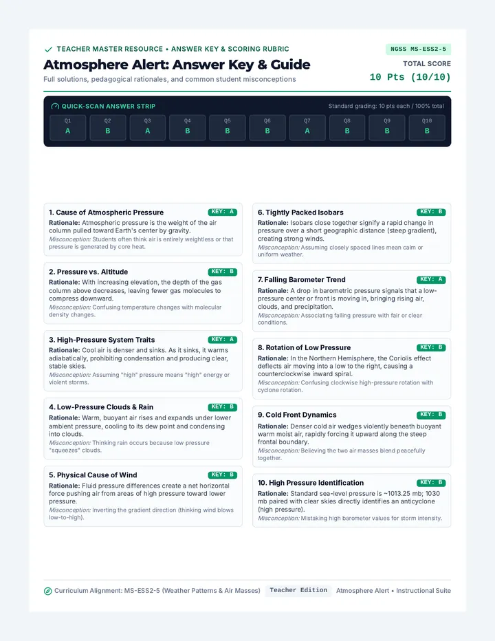
Atmosphere Alert Answer Key
Teacher Master Resource • Answer Key & Scoring Rubric NGSS MS-ESS2-5
Atmosphere Alert: Answer Key & Guide
Full solutions, pedagogical rationales, and common student misconceptions
Total Score 10 Pts (10/10)
Quick-Scan Answer Strip Standard grading: 10 pts each / 100% total
Q1
A
Q2
B
Q3
A
Q4
B
Q5
B
Q6
B
Q7
A
Q8
B
Q9
B
Q10
B
1. Cause of Atmospheric Pressure KEY: A
Rationale: Atmospheric pressure is the weight of the air column pulled toward Earth's center by gravity.
Misconception: Students often think air is entirely weightless or that pressure is generated by core heat.
2. Pressure vs. Altitude KEY: B
Rationale: With increasing elevation, the depth of the gas column above decreases, leaving fewer gas molecules to compress downward.
Misconception: Confusing temperature changes with molecular density changes.
3. High-Pressure System Traits KEY: A
Rationale: Cool air is denser and sinks. As it sinks, it warms adiabatically, prohibiting condensation and producing clear, stable skies.
Misconception: Assuming "high" pressure means "high" energy or violent storms.
4. Low-Pressure Clouds & Rain KEY: B
Rationale: Warm, buoyant air rises and expands under lower ambient pressure, cooling to its dew point and condensing into clouds.
Misconception: Thinking rain occurs because low pressure "squeezes" clouds.
5. Physical Cause of Wind KEY: B
Rationale: Fluid pressure differences create a net horizontal force pushing air from areas of high pressure toward lower pressure.
Misconception: Inverting the gradient direction (thinking wind blows low-to-high).
6. Tightly Packed Isobars KEY: B
Rationale: Isobars close together signify a rapid change in pressure over a short geographic distance (steep gradient), creating strong winds.
Misconception: Assuming closely spaced lines mean calm or uniform weather.
7. Falling Barometer Trend KEY: A
Rationale: A drop in barometric pressure signals that a low-pressure center or front is moving in, bringing rising air, clouds, and precipitation.