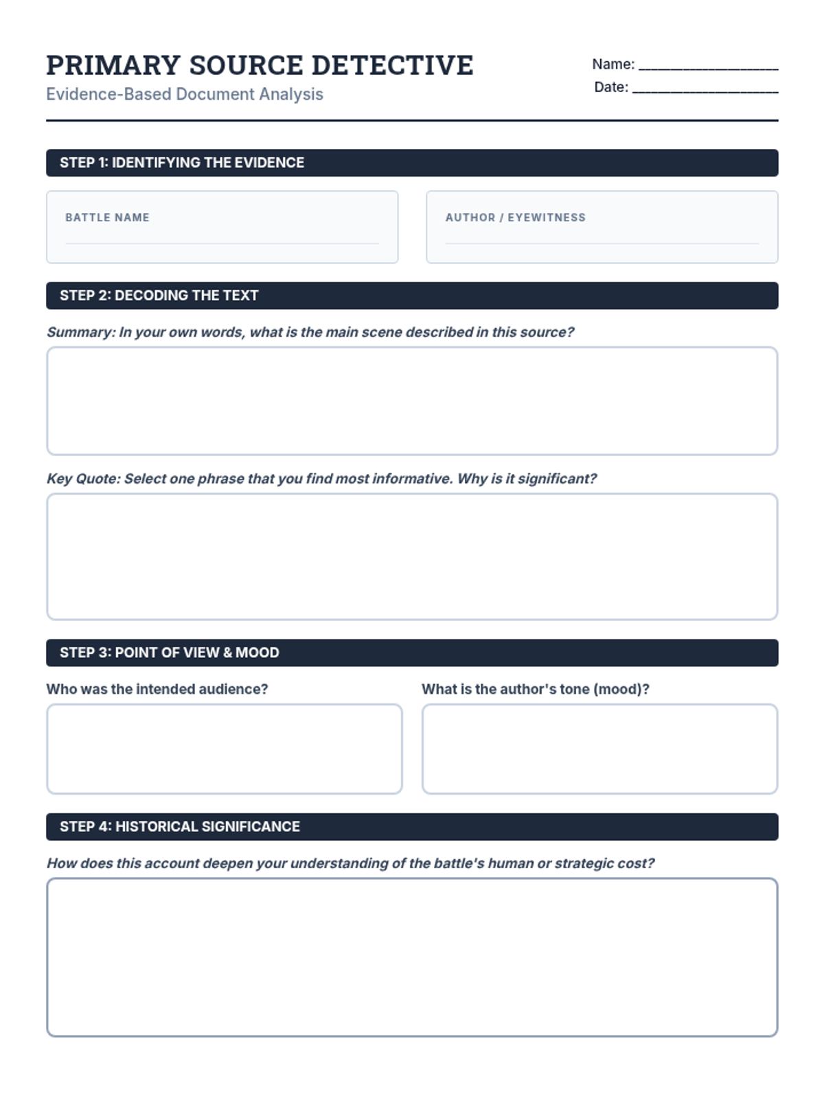
A student worksheet for the 'History Detective' activity, providing structured space for annotating details, reflecting on significance, and drafting an analytical claim.
GED scoring key for the final Mapping Mastery Quiz, providing detailed rationales and evaluation criteria for text interpretation and quantitative map skills.
GED-formatted final mastery quiz focusing on interpreting informational text stimulus, quantitative contour calculations, and synthesizing geographic data for economic analysis.
GED-aligned worksheet for physiographic regions, focusing on interpreting regional text descriptions and analyzing how physical terrain dictates regional economies and industry.
GED-aligned worksheet for topographic maps, focusing on practical terrain application, contour interval math, and visualizing 3D landforms from 2D diagrams.
GED-aligned worksheet for elevation maps, focusing on using legends to make inferences about agricultural suitability, climate shifts, and aviation safety.
GED-aligned worksheet focusing on identifying landforms from text-based stimulus and applying geographic reasoning to transportation and resource scenarios.
Teacher-facing answer key for the Advanced Mapping Mastery Quiz, providing technical geological explanations and mathematical solutions for high-school level analysis.
High-school equivalent final assessment covering geomorphic causality, quantitative hypsometric analysis, and complex physiographic synthesis of North American regions. Improved layout, diagram accuracy, and text contrast.
High-school level worksheet for Lesson 4 focusing on physiographic analysis, tectonic influences on regional formation, and the synthesis of physical geography with economic industrialization patterns. Fixed page breaks and contrast.
Exploration of how the world is divided into physical regions based on landforms, with a specific focus on the seven regions of North America.
High-school level worksheet focusing on gradient calculation, quantitative interpretation of topographic maps, and geomorphological cross-sectioning using the Ithaca, NY case study. Fixed page breaks and MathJax rendering.
Expanded "Contour Secrets" slides with in-depth explanations of index contours, contour interval calculation, and below-sea-level elevation.
High-school level worksheet for Lesson 2 focusing on hypsometric analysis, climate implications of elevation (lapse rate), and technical interpretation of relief maps. Improved contrast and page utilization.
Presentation slides for Lesson 2 covering elevation, sea level, and relief shading on maps, with added sections on climate impact and water flow.
High-school level worksheet focusing on geomorphic processes, technical classification of landforms, and the synthesis of physical geography with human development. Consolidated layout for better page utilization.
Expanded introductory slides for Lesson 1 covering the full range of landforms and bodies of water from the source material, featuring comparative visuals and a deductive challenge.
A teacher-facing unit overview that outlines the lesson sequence, core focus, and essential questions for the Mapping Our World geography unit.
A teacher's guide for facilitating the Civil War Jigsaw activity, including pacing, grouping strategies, a quick-reference answer key, and discussion prompts.
Introductory slides for the Civil War Battles Jigsaw lesson, explaining the jigsaw method and providing an overview of the battles to be studied.
An analysis worksheet for students to examine the primary sources embedded in their battle readings, focusing on evidence identification, decoding, perspective, and historical significance.
A graphic organizer for students to summarize key figures, victors, and strategic significance for all eight Civil War battles discussed in the jigsaw activity.